
Make a donation
Gear up for your next adventure:
As an Amazon Associate, this site earns from qualifying purchases at no extra cost to you.
Valley Haven topographic map
Click on the map to display elevation.
Make a donation
Gear up for your next adventure:
As an Amazon Associate, this site earns from qualifying purchases at no extra cost to you.
About this map
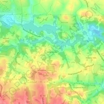
Name: Valley Haven topographic map, elevation, terrain.
Average elevation: 932 ft
Minimum elevation: 804 ft
Maximum elevation: 1,063 ft
Greenville County trails, hiking, mountain biking, running and outdoor activities
Make a donation
Gear up for your next adventure:
As an Amazon Associate, this site earns from qualifying purchases at no extra cost to you.
Other topographic maps
Click on a map to view its topography, its elevation and its terrain.
Wade Hampton
United States > South Carolina > Greenville County > Wildaire
Average elevation: 1,001 ft
Georgia Street Park
United States > South Carolina > Greenville County > Fountain Inn
Average elevation: 843 ft
Make a donation
Gear up for your next adventure:
As an Amazon Associate, this site earns from qualifying purchases at no extra cost to you.
Bald Rock Heritage Preserve
United States > South Carolina > Greenville County
Average elevation: 1,575 ft
Make a donation
Gear up for your next adventure:
As an Amazon Associate, this site earns from qualifying purchases at no extra cost to you.
Chestnut Ridge Heritage Preserve
United States > South Carolina > Greenville County
Average elevation: 1,283 ft
Paris Mountain State Park
United States > South Carolina > Greenville County
Paris Mountain lies in the Piedmont region of the United States. The mountain is a monadnock, a mountain that stands alone in an area. The word "monadnock" comes from Mount Monadnock in New Hampshire. The elevation of Paris Mountain exceeds 2,000 feet (609.6 m). The Piedmont region where Paris Mountain is…
Average elevation: 1,237 ft
Make a donation
Gear up for your next adventure:
As an Amazon Associate, this site earns from qualifying purchases at no extra cost to you.
Ashmore Heritage Preserve
United States > South Carolina > Greenville County
Average elevation: 1,476 ft