
Make a donation
Gear up for your next adventure:
As an Amazon Associate, this site earns from qualifying purchases at no extra cost to you.
Pescara topographic map
Click on the map to display elevation.
Make a donation
Gear up for your next adventure:
As an Amazon Associate, this site earns from qualifying purchases at no extra cost to you.
About this map
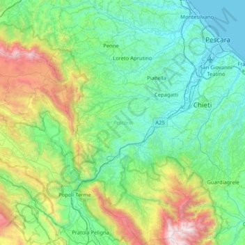
Name: Pescara topographic map, elevation, terrain.
Location: Pescara, Abruzzo, Italy (42.07404 13.76616 42.54549 14.25383)
Average elevation: 1,919 ft
Minimum elevation: -3 ft
Maximum elevation: 9,085 ft
Make a donation
Gear up for your next adventure:
As an Amazon Associate, this site earns from qualifying purchases at no extra cost to you.
Other topographic maps
Click on a map to view its topography, its elevation and its terrain.
Campo Imperatore
Italy > Abruzzo > L'Aquila > L'Aquila
The plateau's altitude ranges from 1,500 to 1,900 meters. It covers an expanse of approximately 80 km2. Campo Imperatore is home to one of Italy's oldest alpine ski resorts. Located on the plateau's western edge, the resort began commercial operation in the 1920s and continues to thrive as a ski resort to this…
Average elevation: 6,745 ft