
Make a donation
Gear up for your next adventure:
As an Amazon Associate, this site earns from qualifying purchases at no extra cost to you.
Red Deer Lake topographic map
Click on the map to display elevation.
Make a donation
Gear up for your next adventure:
As an Amazon Associate, this site earns from qualifying purchases at no extra cost to you.
About this map
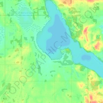
Name: Red Deer Lake topographic map, elevation, terrain.
Location: Red Deer Lake, Camrose County, Alberta, Canada (52.67854 -113.12678 52.76932 -112.99705)
Average elevation: 2,566 ft
Minimum elevation: 2,513 ft
Maximum elevation: 2,694 ft
Make a donation
Gear up for your next adventure:
As an Amazon Associate, this site earns from qualifying purchases at no extra cost to you.
Other topographic maps
Click on a map to view its topography, its elevation and its terrain.
Kingman
Canada > Alberta > Camrose County > Kingman
Kingman is a hamlet in central Alberta, Canada within Camrose County. It is located approximately 27 kilometres (17 mi) north of Camrose and has an elevation of 740 metres (2,430 ft).
Average elevation: 2,451 ft