Geolocate

Watzmann topographic map

Click on the map to display elevation.

About this map

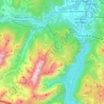
Name: Watzmann topographic map, elevation, terrain.

Location: Watzmann, Ramsau bei Berchtesgaden, Landkreis Berchtesgadener Land, Bavaria, Germany (47.52160 12.88131 47.62594 13.00053)

Average elevation: 3,862 ft

Minimum elevation: 1,781 ft

Maximum elevation: 8,786 ft

Other topographic maps

Click on a map to view its topography, its elevation and its terrain.

Gear up for your next adventure:

🖼️Topo Map Wall Art - Decorative topographic prints of famous peaks and regions
🎒Hydration Pack - Hands‑free water reservoir for long hikes
🎒Day Hiking Backpack - Lightweight backpack perfect for day trips and outdoor adventures
🌎3D Topographic Globes - Raised relief globes for a tactile understanding of geography
🗃️Trail First Aid Kit - Essential kit for outdoor injuries and emergencies

As an Amazon Associate, this site earns from qualifying purchases at no extra cost to you.