Geolocate

Ravenden topographic map

Click on the map to display elevation.

About this map

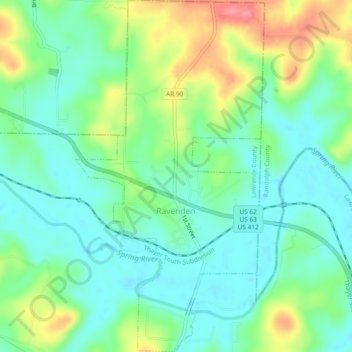
Name: Ravenden topographic map, elevation, terrain.

Location: Ravenden, Lawrence County, Arkansas, 72459, United States (36.22015 -91.26610 36.25795 -91.24076)

Average elevation: 361 ft

Minimum elevation: 272 ft

Maximum elevation: 538 ft

Lawrence County trails, hiking, mountain biking, running and outdoor activities

Other topographic maps

Click on a map to view its topography, its elevation and its terrain.

Mount Olive

United States > Arkansas > Lawrence County

Average elevation: 535 ft

Saffell

United States > Arkansas > Lawrence County

Average elevation: 282 ft

Gear up for your next adventure:

🛌Ultralight Sleeping Bags - Compact down bags for cold nights in the wilderness
📱Heavy-Duty Phone Cases - Drop-proof and waterproof protection for outdoor navigation
🪶Wildlife Field Guides - Learn animal tracking and species ID
📦Dry Bags Set - Waterproof storage for electronics and clothes
🔥Camping Stove - Portable stove for camping and backcountry cooking

As an Amazon Associate, this site earns from qualifying purchases at no extra cost to you.