Geolocate

Saffell topographic map

Click on the map to display elevation.

About this map

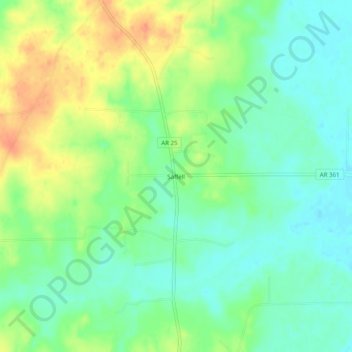
Name: Saffell topographic map, elevation, terrain.

Location: Saffell, Lawrence County, Arkansas, 72572, United States (35.89980 -91.31013 35.93980 -91.27013)

Average elevation: 282 ft

Minimum elevation: 226 ft

Maximum elevation: 364 ft

Lawrence County trails, hiking, mountain biking, running and outdoor activities

Other topographic maps

Click on a map to view its topography, its elevation and its terrain.

Alicia

United States > Arkansas > Lawrence County

Average elevation: 253 ft

Sedgwick

United States > Arkansas > Lawrence County

Average elevation: 256 ft

Strawberry

United States > Arkansas > Lawrence County

Average elevation: 305 ft

Lynn

United States > Arkansas > Lawrence County

Average elevation: 335 ft

Portia

United States > Arkansas > Lawrence County

Average elevation: 259 ft

Walnut Ridge

United States > Arkansas > Lawrence County

Average elevation: 266 ft

Powhatan

United States > Arkansas > Lawrence County

Average elevation: 299 ft

Hoxie

United States > Arkansas > Lawrence County

Average elevation: 266 ft

Black Rock

United States > Arkansas > Lawrence County

Average elevation: 295 ft

Ravenden

United States > Arkansas > Lawrence County

Average elevation: 361 ft

Minturn

United States > Arkansas > Lawrence County

Average elevation: 259 ft

Imboden

United States > Arkansas > Lawrence County

Average elevation: 312 ft

Gear up for your next adventure:

🧭Pro Hiking Compasses - High-accuracy liquid-filled compasses for topographic orientation
🔭Telescopic Hiking Pole - Adjustable pole for hiking stability
🏥Hiking First Aid Kits - Comprehensive medical kits for remote trail injuries
📚USA Hiking Guide Books - Top trail guides and map books
🧥Men's Rain Shells - Premium waterproof and breathable jackets for mountain weather

As an Amazon Associate, this site earns from qualifying purchases at no extra cost to you.