
Make a donation
Gear up for your next adventure:
As an Amazon Associate, this site earns from qualifying purchases at no extra cost to you.
Silvermist Estate topographic map
Click on the map to display elevation.
Make a donation
Gear up for your next adventure:
As an Amazon Associate, this site earns from qualifying purchases at no extra cost to you.
About this map
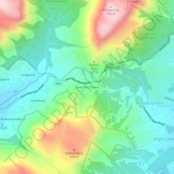
Name: Silvermist Estate topographic map, elevation, terrain.
Average elevation: 892 ft
Minimum elevation: 151 ft
Maximum elevation: 2,461 ft
Make a donation
Gear up for your next adventure:
As an Amazon Associate, this site earns from qualifying purchases at no extra cost to you.
Other topographic maps
Click on a map to view its topography, its elevation and its terrain.
Elsieskraal River
South Africa > Western Cape > City of Cape Town > Cape Town
Average elevation: 36 ft
Newlands Forest
South Africa > Western Cape > City of Cape Town > Cape Town
Average elevation: 1,086 ft
Make a donation
Gear up for your next adventure:
As an Amazon Associate, this site earns from qualifying purchases at no extra cost to you.
Llandudno Beach
South Africa > Western Cape > City of Cape Town > Cape Town > Llandudno
Average elevation: 354 ft