
Elmore topographic map
Interactive map
Click on the map to display elevation.
About this map
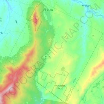
Name: Elmore topographic map, elevation, terrain.
Location: Elmore, Lamoille County, Vermont, 05657, United States (44.42398 -72.59728 44.55341 -72.42981)
Average elevation: 1,385 ft
Minimum elevation: 617 ft
Maximum elevation: 3,235 ft
Elmore is in southeastern Lamoille County, bordered to the south and east by Washington County. A small portion of the town border on the east is with Caledonia County. According to the United States Census Bureau, the town has a total area of 39.7 square miles (102.7 km2), of which 39.1 square miles (101.3 km2) are land and 0.54 square miles (1.4 km2), or 1.38%, are water. Lake Elmore is in the northwest corner of the town, and drains north via Elmore Pond Brook toward the Lamoille River. Elmore village sits at the northern end of the lake. The Worcester Mountains are on the western side of the town. Mt. Elmore, at the northern end of the range, rises to an elevation of 2,608 feet (795 m) to the west of Lake Elmore.
Other topographic maps
Click on a map to view its topography, its elevation and its terrain.
Stowe
United States > Vermont > Lamoille County
Stowe, Lamoille County, Vermont, United States
Average elevation: 1,430 ft
Green Mountains
United States > Vermont > Lamoille County > Cambridge
Green Mountains, Cambridge, Lamoille County, Vermont, United States
Average elevation: 1,736 ft
Morristown
United States > Vermont > Lamoille County
Morristown, Lamoille County, Vermont, 05661, United States
Average elevation: 1,198 ft
Morrisville
United States > Vermont > Lamoille County > Morristown
Morrisville, Morristown, Lamoille County, Vermont, 05661, United States
Average elevation: 719 ft
Hyde Park
United States > Vermont > Lamoille County
Hyde Park, Lamoille County, Vermont, United States
Average elevation: 1,020 ft
Morses Mill
United States > Vermont > Lamoille County > Cambridge
Morses Mill, Cambridge, Lamoille County, Vermont, United States
Average elevation: 1,575 ft
Johnson
United States > Vermont > Lamoille County
Johnson, Lamoille County, Vermont, 05656, United States
Average elevation: 1,201 ft
Lamoille Union Lower Field North
United States > Vermont > Lamoille County > Hyde Park
Lamoille Union Lower Field North, Hyde Park, Lamoille County, Vermont, United States
Average elevation: 682 ft
Jeffersonville
United States > Vermont > Lamoille County
Jeffersonville, Cambridge, Lamoille County, Vermont, 05464, United States
Average elevation: 617 ft
Lower Village
United States > Vermont > Lamoille County > Stowe
Lower Village, Stowe, Lamoille County, Vermont, 05672, United States
Average elevation: 866 ft
Waterville
United States > Vermont > Lamoille County > Waterville
Waterville, Lamoille County, Vermont, 05492, United States
Average elevation: 1,119 ft
Cambridge
United States > Vermont > Lamoille County
Cambridge, Lamoille County, Vermont, United States
Average elevation: 1,033 ft
Eden
United States > Vermont > Lamoille County
Eden, Lamoille County, Vermont, United States
Average elevation: 1,444 ft