Geolocate

Fingringhoe topographic map

Click on the map to display elevation.

About this map

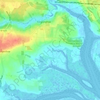
Name: Fingringhoe topographic map, elevation, terrain.

Location: Fingringhoe, Rowhedge, Colchester, Essex, England, United Kingdom (51.80965 0.91432 51.85454 0.99348)

Average elevation: 33 ft

Minimum elevation: -10 ft

Maximum elevation: 148 ft

Other topographic maps

Click on a map to view its topography, its elevation and its terrain.

Berechurch

United Kingdom > England > Essex > Colchester

Average elevation: 92 ft

Layer-de-la-Haye

United Kingdom > England > Essex > Colchester

Average elevation: 95 ft

Wivenhoe Woods

United Kingdom > England > Essex > Colchester > Wivenhoe > Rowhedge

Average elevation: 59 ft

Boxted Cross

United Kingdom > England > Essex > Colchester > Boxted

Average elevation: 125 ft

Rowhedge

United Kingdom > England > Essex > Colchester

Average elevation: 66 ft

Birch Green

United Kingdom > England > Essex > Colchester

Average elevation: 115 ft

Messing

United Kingdom > England > Essex > Colchester

Average elevation: 148 ft

Salcott

United Kingdom > England > Essex > Colchester > Salcott

Average elevation: 46 ft

Dedham Vale

United Kingdom > England > Essex > Colchester > Dedham

Average elevation: 49 ft

Inworth

United Kingdom > England > Essex > Colchester

Average elevation: 151 ft

Gear up for your next adventure:

🕶️Glacier Sunglasses - Side shields to protect eyes from high-altitude snow glare
🛡️Bear Spray Outdoor - Protection in bear country hikes
🔪Outdoor Multitools - Essential survival tools for gear repair and field use
🛰️Satellite Messengers - Emergency SOS and two-way messaging for off-grid adventures
🔋Rechargeable Batteries - Power up your outdoor devices

As an Amazon Associate, this site earns from qualifying purchases at no extra cost to you.