Geolocate

Messing topographic map

Click on the map to display elevation.

About this map

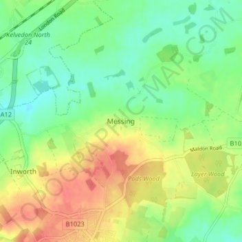
Name: Messing topographic map, elevation, terrain.

Location: Messing, Colchester, Essex, England, CO5 9TT, United Kingdom (51.81662 0.73253 51.85662 0.77253)

Average elevation: 148 ft

Minimum elevation: 72 ft

Maximum elevation: 246 ft

Other topographic maps

Click on a map to view its topography, its elevation and its terrain.

Wakes Colne

United Kingdom > England > Essex > Colchester > Wakes Colne

Average elevation: 177 ft

Mersea Island

United Kingdom > England > Essex > Colchester > East Mersea

Average elevation: 13 ft

Mount Bures

United Kingdom > England > Essex > Colchester

Average elevation: 177 ft

Peldon

United Kingdom > England > Essex > Colchester > Peldon

Average elevation: 49 ft

West Mersea

United Kingdom > England > Essex > Colchester

Average elevation: 20 ft

Langham

United Kingdom > England > Essex > Colchester > Langham

Average elevation: 115 ft

Birch

United Kingdom > England > Essex > Colchester > Birch

Average elevation: 118 ft

Wivenhoe Woods

United Kingdom > England > Essex > Colchester > Wivenhoe > Rowhedge

Average elevation: 59 ft

Great Tey

United Kingdom > England > Essex > Colchester > Great Tey

Average elevation: 167 ft

Aldham

United Kingdom > England > Essex > Colchester > Aldham

Average elevation: 128 ft

Stanway

United Kingdom > England > Essex > Colchester

Average elevation: 118 ft

Salcott

United Kingdom > England > Essex > Colchester > Salcott

Average elevation: 26 ft

Chappel

United Kingdom > England > Essex > Colchester

Average elevation: 144 ft

Marks Tey

United Kingdom > England > Essex > Colchester

Average elevation: 131 ft

Langenhoe

United Kingdom > England > Essex > Colchester > Langenhoe

Average elevation: 36 ft

Fingringhoe

United Kingdom > England > Essex > Colchester

Average elevation: 33 ft

Layer Breton

United Kingdom > England > Essex > Colchester > Layer Breton

Average elevation: 98 ft

Wivenhoe

United Kingdom > England > Essex > Colchester > Rowhedge

Average elevation: 69 ft

Gear up for your next adventure:

📱Heavy-Duty Phone Cases - Drop-proof and waterproof protection for outdoor navigation
🧼Biodegradable Camping Soap - Eco‑friendly soap for outdoor hygiene
🚗GPS Dash Cams - Record your scenic drives through mountain passes and canyons
🥾Hiking Shoes - Durable and comfortable shoes for trail hiking
🎒Day Hiking Backpack - Lightweight backpack perfect for day trips and outdoor adventures

As an Amazon Associate, this site earns from qualifying purchases at no extra cost to you.