
Make a donation
Gear up for your next adventure:
As an Amazon Associate, this site earns from qualifying purchases at no extra cost to you.
West Malvern topographic map
Click on the map to display elevation.
Make a donation
Gear up for your next adventure:
As an Amazon Associate, this site earns from qualifying purchases at no extra cost to you.
West Malvern
West Malvern is a village and a civil parish on the west side of the north part of the Malvern Hills, on the western edge of Worcestershire, England. It has become effectively a suburb of Malvern and part of an urban area often called The Malverns, locally administered by Malvern Hills District Council and its own parish council. Its altitude up to 250 metres gives West Malvern panoramic views of the Herefordshire countryside to the west. The Church of St James, built in 1840, has an adjacent Church of England primary school. The churchyard includes the grave of Peter Mark Roget, author of Roget's Thesaurus, who died while on holiday in the village. The 2011 Census population of 1,385 was estimated at 1,263 in 2019.
Make a donation
Gear up for your next adventure:
As an Amazon Associate, this site earns from qualifying purchases at no extra cost to you.
About this map
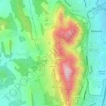
Name: West Malvern topographic map, elevation, terrain.
Average elevation: 650 ft
Minimum elevation: 262 ft
Maximum elevation: 1,388 ft
Make a donation
Gear up for your next adventure:
As an Amazon Associate, this site earns from qualifying purchases at no extra cost to you.
Other topographic maps
Click on a map to view its topography, its elevation and its terrain.
Malvern
United Kingdom > England > Worcestershire > Malvern Hills
Malvern lies in the Lower Severn/Avon plain affording it a degree of shelter caused by virtue of its nestling in between the Cotswold hills to the east, the Welsh Hills and Mountains to the west, and Birmingham plateau to the north. Although as with all the British Isles it has a maritime climate, the local…
Average elevation: 312 ft
Upper Broadheath
United Kingdom > England > Worcestershire > Malvern Hills > Crown East
Average elevation: 144 ft
Make a donation
Gear up for your next adventure:
As an Amazon Associate, this site earns from qualifying purchases at no extra cost to you.
Make a donation
Gear up for your next adventure:
As an Amazon Associate, this site earns from qualifying purchases at no extra cost to you.
Corse Lawn
United Kingdom > England > Worcestershire > Malvern Hills > Eldersfield
Average elevation: 85 ft
Bastonford
United Kingdom > England > Worcestershire > Malvern Hills > Powick
Average elevation: 121 ft
The Hill, Abberley
United Kingdom > England > Worcestershire > Malvern Hills > Abberley
Average elevation: 433 ft
Elms Green
United Kingdom > England > Worcestershire > Malvern Hills > Abberley
Average elevation: 397 ft
Make a donation
Gear up for your next adventure:
As an Amazon Associate, this site earns from qualifying purchases at no extra cost to you.
Table Hill
United Kingdom > England > Worcestershire > Malvern Hills
Table Hill is situated in the range of Malvern Hills that runs about 13 kilometres (8 mi) north-south along the Herefordshire-Worcestershire border. It lies between North Hill and Sugarloaf Hill and has an elevation of 373 metres (1,224 ft).
Average elevation: 617 ft
Stonehall
United Kingdom > England > Worcestershire > Malvern Hills > Kempsey
Average elevation: 128 ft
Make a donation
Gear up for your next adventure:
As an Amazon Associate, this site earns from qualifying purchases at no extra cost to you.
Beach Hay
United Kingdom > England > Worcestershire > Malvern Hills > Bayton
Average elevation: 499 ft
Malvern
United Kingdom > England > Worcestershire > Malvern Hills
Malvern lies in the Lower Severn/Avon plain affording it a degree of shelter caused by virtue of its nestling in between the Cotswold hills to the east, the Welsh Hills and Mountains to the west, and Birmingham plateau to the north. Although as with all the British Isles it has a maritime climate, the local…
Average elevation: 312 ft
Make a donation
Gear up for your next adventure:
As an Amazon Associate, this site earns from qualifying purchases at no extra cost to you.
Whiteacres
United Kingdom > England > Worcestershire > Malvern Hills > Powick
Average elevation: 89 ft
Worcestershire Beacon
United Kingdom > England > Worcestershire > Malvern Hills
Average elevation: 646 ft
Malvern
United Kingdom > England > Worcestershire > Malvern Hills
Malvern lies in the Lower Severn/Avon plain affording it a degree of shelter caused by virtue of its nestling in between the Cotswold hills to the east, the Welsh Hills and Mountains to the west, and Birmingham plateau to the north. Although as with all the British Isles it has a maritime climate, the local…
Average elevation: 312 ft
Make a donation
Gear up for your next adventure:
As an Amazon Associate, this site earns from qualifying purchases at no extra cost to you.