Geolocate

Table Hill topographic map

Click on the map to display elevation.

Table Hill

Table Hill is situated in the range of Malvern Hills that runs about 13 kilometres (8 mi) north-south along the Herefordshire-Worcestershire border. It lies between North Hill and Sugarloaf Hill and has an elevation of 373 metres (1,224 ft).

Wikipedia (CC-BY-SA 3.0)

About this map

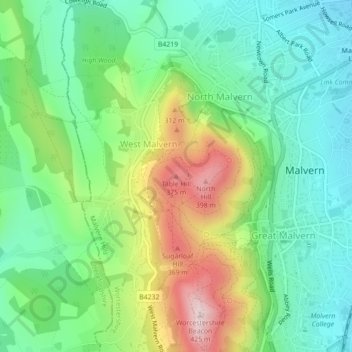
Name: Table Hill topographic map, elevation, terrain.

Location: Table Hill, Malvern Hills, Worcestershire, England, WR14 4AY, United Kingdom (52.11546 -2.34201 52.11556 -2.34191)

Average elevation: 617 ft

Minimum elevation: 223 ft

Maximum elevation: 1,388 ft

Other topographic maps

Click on a map to view its topography, its elevation and its terrain.

West Malvern

United Kingdom > England > Worcestershire > Malvern Hills

West Malvern is a village and a civil parish on the west side of the north part of the Malvern Hills, on the western edge of Worcestershire, England. It has become effectively a suburb of Malvern and part of an urban area often called The Malverns, locally administered by Malvern Hills District Council and its…

Average elevation: 650 ft

Hanley

United Kingdom > England > Worcestershire > Malvern Hills

Average elevation: 518 ft

Bockleton

United Kingdom > England > Worcestershire > Malvern Hills

Average elevation: 561 ft

Holt

United Kingdom > England > Worcestershire > Malvern Hills

Average elevation: 197 ft

Longdon

United Kingdom > England > Worcestershire > Malvern Hills

Average elevation: 79 ft

Bransford

United Kingdom > England > Worcestershire > Malvern Hills

Average elevation: 131 ft

Hallow

United Kingdom > England > Worcestershire > Malvern Hills

Average elevation: 121 ft

Rushwick

United Kingdom > England > Worcestershire > Malvern Hills

Average elevation: 102 ft

Kempsey

United Kingdom > England > Worcestershire > Malvern Hills

Average elevation: 92 ft

Welland

United Kingdom > England > Worcestershire > Malvern Hills

Average elevation: 167 ft

Berrow

United Kingdom > England > Worcestershire > Malvern Hills

Average elevation: 115 ft

Bayton

United Kingdom > England > Worcestershire > Malvern Hills

Average elevation: 463 ft

Broadwas

United Kingdom > England > Worcestershire > Malvern Hills

Average elevation: 141 ft

Lindridge

United Kingdom > England > Worcestershire > Malvern Hills

Average elevation: 351 ft

Leigh

United Kingdom > England > Worcestershire > Malvern Hills

Average elevation: 157 ft

Suckley

United Kingdom > England > Worcestershire > Malvern Hills

Average elevation: 315 ft

Alfrick

United Kingdom > England > Worcestershire > Malvern Hills

Average elevation: 256 ft

Powick

United Kingdom > England > Worcestershire > Malvern Hills

Average elevation: 92 ft

Bushley

United Kingdom > England > Worcestershire > Malvern Hills

Average elevation: 82 ft

Grimley

United Kingdom > England > Worcestershire > Malvern Hills

Average elevation: 121 ft

Mamble

United Kingdom > England > Worcestershire > Malvern Hills

Average elevation: 423 ft

Abberley

United Kingdom > England > Worcestershire > Malvern Hills

Average elevation: 400 ft

Pensax

United Kingdom > England > Worcestershire > Malvern Hills

Average elevation: 430 ft

Shrawley

United Kingdom > England > Worcestershire > Malvern Hills

Average elevation: 151 ft

Ripple

United Kingdom > England > Worcestershire > Malvern Hills

Average elevation: 69 ft

Martley

United Kingdom > England > Worcestershire > Malvern Hills

Average elevation: 249 ft

Bransford

United Kingdom > England > Worcestershire > Malvern Hills

Average elevation: 131 ft

Gear up for your next adventure:

📦Gear Storage Bags - Organize and protect outdoor equipment
🎒Trail Energy Bars - High‑calorie bars for hiking energy
🧷Carabiner Set - Durable clips for gear attachment
🧭Pro Hiking Compasses - High-accuracy liquid-filled compasses for topographic orientation
👖Convertible Hiking Pants - Versatile zip-off pants for changing altitudes and temperatures

As an Amazon Associate, this site earns from qualifying purchases at no extra cost to you.