
Make a donation
Gear up for your next adventure:
As an Amazon Associate, this site earns from qualifying purchases at no extra cost to you.
Schmerbroich topographic map
Click on the map to display elevation.
Make a donation
Gear up for your next adventure:
As an Amazon Associate, this site earns from qualifying purchases at no extra cost to you.
About this map
Name: Schmerbroich topographic map, elevation, terrain.
Average elevation: 276 ft
Minimum elevation: 190 ft
Maximum elevation: 476 ft
Make a donation
Gear up for your next adventure:
As an Amazon Associate, this site earns from qualifying purchases at no extra cost to you.
Other topographic maps
Click on a map to view its topography, its elevation and its terrain.
Mülldorf
Deutschland > Nordrhein-Westfalen > Rhein-Sieg-Kreis > Sankt Augustin
1890 trat erstmals der Löschzug (LZ) als Feuer-Corps bei einem Zusammenschluss von Bürgern Siegburg-Mülldorfs und Mendens auf. Heute jedoch ist er Teil der Freiwilligen Feuerwehr Sankt Augustin als Löschzug Mülldorf. Als Feuerwehrhaus wird seit 1965 das Haus an der Gartenstraßen genutzt. In diesem ist…
Average elevation: 203 ft
Hangelar
Deutschland > Nordrhein-Westfalen > Rhein-Sieg-Kreis > Sankt Augustin
Hangelar liegt im Südosten der Kölner Bucht, innerhalb derer es sich naturräumlich den Menden-Hangelarer Terrassen zuordnen lässt, wobei die Ortschaft selbst sich etwas erhöht auf der durch eine Flugsanddecke überformten Mittelterrasse befindet. Diese stellt den Übergang zum sich nach Süden…
Average elevation: 246 ft
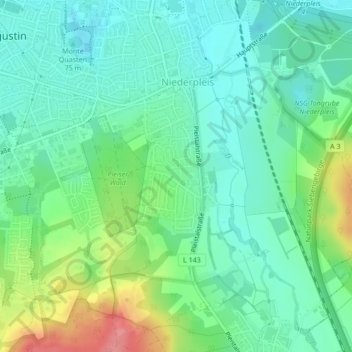
Niederpleis
Deutschland > Nordrhein-Westfalen > Rhein-Sieg-Kreis > Sankt Augustin
Niederpleis liegt auf 65 m ü. NHN, acht Kilometer nordöstlich der Stadt Bonn und zwei Kilometer südlich der Kreisstadt Siegburg. Die Ortschaft erstreckt sich am Rande des Verdichtungsraumes Bonn in der Siegniederung und am Übergang in das nach Süden ansteigende Pleiser Hügelland. Im Norden geht die…
Average elevation: 262 ft
Make a donation
Gear up for your next adventure:
As an Amazon Associate, this site earns from qualifying purchases at no extra cost to you.
Birlinghoven
Deutschland > Nordrhein-Westfalen > Rhein-Sieg-Kreis > Sankt Augustin
Birlinghoven liegt im Südosten des Stadtgebietes von Sankt Augustin, etwa 4 km vom Zentrum der Stadt entfernt. Naturräumlich lässt es sich dem nach Süden hin ansteigenden Pleiser Hügelland zuordnen. Nach Nordosten fällt die Ortschaft zum Tal des Pleisbachs ab, dem unterhalb von ihr der Birlinghoven…
Average elevation: 348 ft
Menden
Deutschland > Nordrhein-Westfalen > Rhein-Sieg-Kreis > Sankt Augustin
Average elevation: 187 ft
Meindorf
Deutschland > Nordrhein-Westfalen > Rhein-Sieg-Kreis > Sankt Augustin
Meindorf liegt auf einer Anhöhe über dem Lauf der Sieg, die ca. vier Kilometer westlich in den Rhein mündet.
Average elevation: 177 ft
Buisdorf
Deutschland > Nordrhein-Westfalen > Rhein-Sieg-Kreis > Sankt Augustin
Average elevation: 253 ft
Make a donation
Gear up for your next adventure:
As an Amazon Associate, this site earns from qualifying purchases at no extra cost to you.
Hangelar
Deutschland > Nordrhein-Westfalen > Rhein-Sieg-Kreis > Sankt Augustin
Hangelar liegt im Südosten der Kölner Bucht, innerhalb derer es sich naturräumlich den Menden-Hangelarer Terrassen zuordnen lässt, wobei die Ortschaft selbst sich etwas erhöht auf der durch eine Flugsanddecke überformten Mittelterrasse befindet. Diese stellt den Übergang zum sich nach Süden…
Average elevation: 246 ft
Meindorf
Deutschland > Nordrhein-Westfalen > Rhein-Sieg-Kreis > Sankt Augustin
Meindorf liegt auf einer Anhöhe über dem Lauf der Sieg, die ca. vier Kilometer westlich in den Rhein mündet.
Average elevation: 177 ft