
Make a donation
Gear up for your next adventure:
As an Amazon Associate, this site earns from qualifying purchases at no extra cost to you.
Birlinghoven topographic map
Click on the map to display elevation.
Make a donation
Gear up for your next adventure:
As an Amazon Associate, this site earns from qualifying purchases at no extra cost to you.
Birlinghoven
Birlinghoven liegt im Südosten des Stadtgebietes von Sankt Augustin, etwa 4 km vom Zentrum der Stadt entfernt. Naturräumlich lässt es sich dem nach Süden hin ansteigenden Pleiser Hügelland zuordnen. Nach Nordosten fällt die Ortschaft zum Tal des Pleisbachs ab, dem unterhalb von ihr der Birlinghoven durchquerende Lauterbach zufließt. Die zusammenhängende Bebauung des Stadtbezirks umfasst Höhenlagen von 75 bis 110 m ü. NHN.
Make a donation
Gear up for your next adventure:
As an Amazon Associate, this site earns from qualifying purchases at no extra cost to you.
About this map
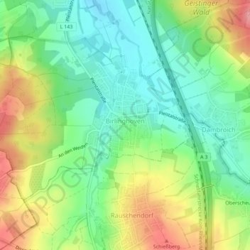
Name: Birlinghoven topographic map, elevation, terrain.
Average elevation: 348 ft
Minimum elevation: 226 ft
Maximum elevation: 531 ft
Make a donation
Gear up for your next adventure:
As an Amazon Associate, this site earns from qualifying purchases at no extra cost to you.
Other topographic maps
Click on a map to view its topography, its elevation and its terrain.
Schmerbroich
Deutschland > Nordrhein-Westfalen > Rhein-Sieg-Kreis > Sankt Augustin
Average elevation: 276 ft