Geolocate

Alhambra topographic map

Click on the map to display elevation.

About this map
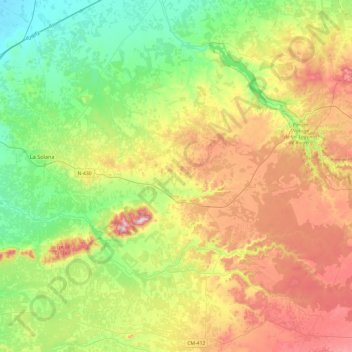
Name: Alhambra topographic map, elevation, terrain.

Location: Alhambra, Ciudad Real, Castile-La Mancha, 13248, Spain (38.74233 -3.28611 39.09889 -2.80501)

Average elevation: 2,667 ft

Minimum elevation: 2,133 ft

Maximum elevation: 3,530 ft

Other topographic maps

Click on a map to view its topography, its elevation and its terrain.
Rio Júcar

Spain > Castile-La Mancha > Cuenca

Average elevation: 3,133 ft

Huelga del Escobar

Spain > Castile-La Mancha > Uña

Average elevation: 4,052 ft

El Encaño

Spain > Castile-La Mancha > Buenache de Alarcón

Average elevation: 2,874 ft

La Sotama

Spain > Castile-La Mancha > Sigüenza > Riba de Santiuste

Average elevation: 3,219 ft

El Alto

Spain > Castile-La Mancha > Sigüenza

Average elevation: 3,704 ft

Aragosa

Spain > Castile-La Mancha > Aragosa

Average elevation: 3,291 ft

El Cobato

Spain > Castile-La Mancha > Cuenca > Huete

Average elevation: 3,127 ft

Gear up for your next adventure:

🔦LED Headlamp - Bright and durable LED headlamp for night navigation
🪶Camp Gear Gift Set - Perfect gift bundle for outdoor fans
🔦Powerful Headlamps - Ultra-bright hands-free lighting for night navigation
🔭Telescopic Hiking Pole - Adjustable pole for hiking stability
⛺Backpacking Tent - Lightweight and durable tent for multi‑day hikes

As an Amazon Associate, this site earns from qualifying purchases at no extra cost to you.