Geolocate

Menlo topographic map

Click on the map to display elevation.

About this map

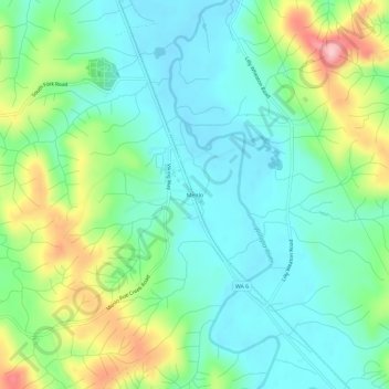
Name: Menlo topographic map, elevation, terrain.

Location: Menlo, Pacific County, Washington, United States (46.60149 -123.66710 46.64149 -123.62710)

Average elevation: 200 ft

Minimum elevation: 20 ft

Maximum elevation: 640 ft

Pacific County trails, hiking, mountain biking, running and outdoor activities

Other topographic maps

Click on a map to view its topography, its elevation and its terrain.

South Bend

United States > Washington > Pacific County

Average elevation: 75 ft

Chinook

United States > Washington > Pacific County

Average elevation: 10 ft

Bay Center

United States > Washington > Pacific County

Average elevation: 10 ft

Gear up for your next adventure:

🦺Reflective Outdoor Gear - Safety gear for low‑light conditions
🕶️GPS Smartphone Mount - Secure mount for phone navigation
🪶Multi‑Purpose Knife - Useful blade for camp and trail
🥘Titanium Cookware - Durable, featherlight pots and pans for backpacking
🔭Telescopic Hiking Pole - Adjustable pole for hiking stability

As an Amazon Associate, this site earns from qualifying purchases at no extra cost to you.