Geolocate

Chinook topographic map

Click on the map to display elevation.

About this map

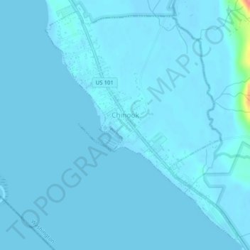
Name: Chinook topographic map, elevation, terrain.

Location: Chinook, Pacific County, Washington, United States (46.25941 -123.95792 46.28405 -123.92784)

Average elevation: 10 ft

Minimum elevation: -7 ft

Maximum elevation: 269 ft

Pacific County trails, hiking, mountain biking, running and outdoor activities

Other topographic maps

Click on a map to view its topography, its elevation and its terrain.

Nemah

United States > Washington > Pacific County

Average elevation: 62 ft

Fort Canby

United States > Washington > Pacific County

Average elevation: 33 ft

Globe

United States > Washington > Pacific County

Average elevation: 338 ft

Menlo

United States > Washington > Pacific County

Average elevation: 200 ft

Gear up for your next adventure:

🛶Inflatable Kayak - Portable kayak for rivers, lakes, and expeditions
🪶Compact Camp Shovel - Folding shovel for campsite tasks
🥾Men's Hiking Boots - Durable, waterproof footwear for rugged terrain and steep inclines
🥄Camping Utensil Set - Lightweight utensils for outdoor meals
🥤Water Filter Bottle - All‑in‑one filter bottle for safe hydration

As an Amazon Associate, this site earns from qualifying purchases at no extra cost to you.