Geolocate

Meishan topographic map

Click on the map to display elevation.

About this map

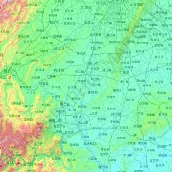
Name: Meishan topographic map, elevation, terrain.

Location: Meishan, Sichuan, 620400, China (29.40291 102.84672 30.36444 104.50146)

Average elevation: 2,208 ft

Minimum elevation: 1,027 ft

Maximum elevation: 11,562 ft

Other topographic maps

Click on a map to view its topography, its elevation and its terrain.

Xuanhan

China > Sichuan > Xuanhan County

Average elevation: 1,811 ft

Zigong

China > Sichuan

Average elevation: 1,093 ft

Luzhou

China > Sichuan

Average elevation: 1,037 ft

Guangyuan

China > Sichuan

Average elevation: 2,641 ft

Yibin

China > Sichuan

Average elevation: 1,273 ft

Ngawa

China > Sichuan > Ngawa County

Average elevation: 12,283 ft

Jiuzhaigou

China > Sichuan > Jiuzhaigou County

The county consists of nine villages in a valley in Sichuan Province. The main ethnic group in the county is Han, with the second being Tibetan. The county seat has an altitude of about 1,400 m (4,600 ft). It has a total area of 2,041 square miles (5,286 km2). As of 2015, the county's total population was…

Average elevation: 8,268 ft

巴拉格宗雪山

China > Sichuan > Dêrong County

Average elevation: 15,656 ft

Barkam

China > Sichuan > Barkam

Average elevation: 12,244 ft

Mount Emei

China > Sichuan

Average elevation: 8,015 ft

Gear up for your next adventure:

🕶️GPS Smartphone Mount - Secure mount for phone navigation
🌲Outdoor Survival Books - Best books on survival skills
😴Insulated Sleeping Pads - Compact and warm pads for high-elevation camping
🔪Outdoor Multitools - Essential survival tools for gear repair and field use
🪶Thermal Camp Blanket - Extra warmth for cold nights

As an Amazon Associate, this site earns from qualifying purchases at no extra cost to you.