Geolocate

Lonedell topographic map

Click on the map to display elevation.

About this map

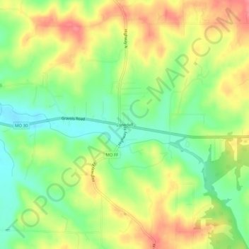
Name: Lonedell topographic map, elevation, terrain.

Location: Lonedell, Franklin County, Missouri, 63063, United States (38.28811 -90.84763 38.32811 -90.80763)

Average elevation: 646 ft

Minimum elevation: 525 ft

Maximum elevation: 778 ft

Franklin County trails, hiking, mountain biking, running and outdoor activities

Other topographic maps

Click on a map to view its topography, its elevation and its terrain.

St. Clair

United States > Missouri > Franklin County

Average elevation: 696 ft

Union

United States > Missouri > Franklin County

Average elevation: 623 ft

Pacific

United States > Missouri > Franklin County

Average elevation: 568 ft

Gerald

United States > Missouri > Franklin County

Average elevation: 873 ft

Pacific

United States > Missouri > Franklin County

Average elevation: 568 ft

Berger

United States > Missouri > Franklin County

Average elevation: 561 ft

Berger

United States > Missouri > Franklin County

Average elevation: 561 ft

Gear up for your next adventure:

🧣Hiking Neck Gaiter - Multi‑use neck protection for outdoor weather
📚Navigation Handbooks - Master the art of reading topographic maps and using a compass
🛡️Insect Repellent - Protection against bugs during outdoor activities
🥇GPS Hiking Watch - Multi‑sport GPS watch with navigation and trail tracking
📻Weather Alert Radios - Stay informed of storm risks while off-the-grid

As an Amazon Associate, this site earns from qualifying purchases at no extra cost to you.