
Union topographic map
Click on the map to display elevation.
About this map
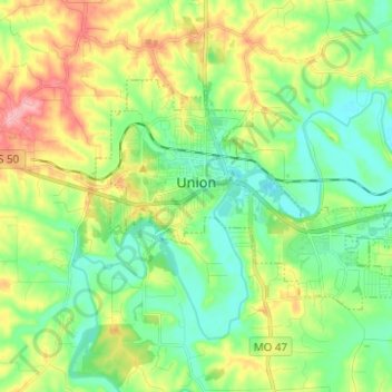
Name: Union topographic map, elevation, terrain.
Location: Union, Franklin County, Missouri, United States (38.41202 -91.04037 38.46976 -90.91627)
Average elevation: 623 ft
Minimum elevation: 486 ft
Maximum elevation: 879 ft
Franklin County trails, hiking, mountain biking, running and outdoor activities
Other topographic maps
Click on a map to view its topography, its elevation and its terrain.