Geolocate

Alexandria topographic map

Click on the map to display elevation.

About this map

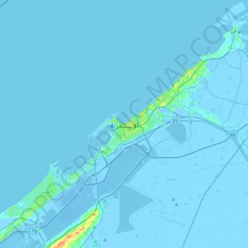
Name: Alexandria topographic map, elevation, terrain.

Location: Alexandria, 21519, Egypt (31.03918 29.73517 31.35918 30.05517)

Average elevation: 0 ft

Minimum elevation: -36 ft

Maximum elevation: 164 ft

Other topographic maps

Click on a map to view its topography, its elevation and its terrain.

Buhayrat Maryut

Egypt > Alexandria > Alexandria

Average elevation: -13 ft

Al-Montaza Park

Egypt > Alexandria > Al Mandarah

Average elevation: 7 ft

Abou Zahrah

Egypt > Alexandria

Average elevation: 184 ft

New Borg Al Arab City

Egypt > Alexandria

Average elevation: 118 ft

Abou Qir East

Egypt > Alexandria > Abu Qir

Average elevation: 0 ft

Gear up for your next adventure:

🗺️NatGeo Topo Maps - High-quality waterproof printed topographic maps of US Parks
🥄Camping Utensil Set - Lightweight utensils for outdoor meals
🔋Solar Power Banks - Keep your GPS and phone charged in remote wilderness areas
🚑Emergency Bivvies - Heat-reflective sleeping bags for survival situations
Solar GPS Watches - Advanced multisport watches with built-in topographic maps

As an Amazon Associate, this site earns from qualifying purchases at no extra cost to you.