Geolocate

Cole Camp topographic map

Click on the map to display elevation.

About this map

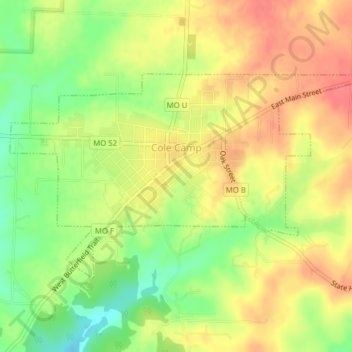
Name: Cole Camp topographic map, elevation, terrain.

Location: Cole Camp, Benton County, Missouri, 65325, United States (38.44855 -93.22128 38.46646 -93.18213)

Average elevation: 1,024 ft

Minimum elevation: 906 ft

Maximum elevation: 1,115 ft

Benton County trails, hiking, mountain biking, running and outdoor activities

Other topographic maps

Click on a map to view its topography, its elevation and its terrain.

Brandon

United States > Missouri > Benton County

Average elevation: 922 ft

White Branch

United States > Missouri > Benton County

Average elevation: 738 ft

Palo Pinto

United States > Missouri > Benton County

Average elevation: 833 ft

Edwards

United States > Missouri > Benton County

Average elevation: 850 ft

Gear up for your next adventure:

📚USA Hiking Guide Books - Top trail guides and map books
🎁Geography Themed Gifts - Unique gift ideas for map lovers and geography enthusiasts
📷Action Cameras - Rugged cameras to document your journeys across rugged terrain
📷Action Camera - Capture your outdoor adventures in HD
🔭Stargazing Telescopes - Perfect for camping in low-light pollution areas shown on maps

As an Amazon Associate, this site earns from qualifying purchases at no extra cost to you.