
Make a donation
Gear up for your next adventure:
As an Amazon Associate, this site earns from qualifying purchases at no extra cost to you.
Franklin Mountain topographic map
Click on the map to display elevation.
Make a donation
Gear up for your next adventure:
As an Amazon Associate, this site earns from qualifying purchases at no extra cost to you.
About this map
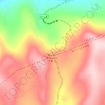
Name: Franklin Mountain topographic map, elevation, terrain.
Average elevation: 1,749 ft
Minimum elevation: 1,122 ft
Maximum elevation: 2,136 ft
Otsego County trails, hiking, mountain biking, running and outdoor activities
Make a donation
Gear up for your next adventure:
As an Amazon Associate, this site earns from qualifying purchases at no extra cost to you.
Other topographic maps
Click on a map to view its topography, its elevation and its terrain.
South Edmeston
United States > New York > Otsego County > Town of Edmeston
Average elevation: 1,266 ft
Canadarago Lake
United States > New York > Otsego County > Town of Richfield
It is geologically related to the Finger Lakes, as they were both carved by glaciers, but is not counted among them. One difference is that Canadarago Lake is situated at a higher elevation (1,266 feet [386 m]) than the Finger Lakes (approximately 400 feet [122 m]). Another difference is the Finger Lakes are…
Average elevation: 1,453 ft
Make a donation
Gear up for your next adventure:
As an Amazon Associate, this site earns from qualifying purchases at no extra cost to you.
Burlington Flats
United States > New York > Otsego County > Town of Burlington
Average elevation: 1,470 ft
Make a donation
Gear up for your next adventure:
As an Amazon Associate, this site earns from qualifying purchases at no extra cost to you.
Town of Edmeston
United States > New York > Otsego County
The elevation of the town varies by approximately 800 feet (240 m): from just under 1,100 feet (340 m) above sea level at the Unadilla River in the southwestern corner of the town, to just over 1,900 feet (580 m) at peaks near Taylor Hill and Summit Lake in the northeastern corner.
Average elevation: 1,447 ft
Make a donation
Gear up for your next adventure:
As an Amazon Associate, this site earns from qualifying purchases at no extra cost to you.
Town of Westford
United States > New York > Otsego County > Town of Westford
Average elevation: 1,778 ft
Town of Exeter
United States > New York > Otsego County
The eastern town line borders, in part, Canadarago Lake. Wharton Creek flows down the western side of the town. Angel Hill is an elevation near the southern town line.
Average elevation: 1,594 ft
Make a donation
Gear up for your next adventure:
As an Amazon Associate, this site earns from qualifying purchases at no extra cost to you.