
Make a donation
Gear up for your next adventure:
As an Amazon Associate, this site earns from qualifying purchases at no extra cost to you.
Town of Otego topographic map
Click on the map to display elevation.
Make a donation
Gear up for your next adventure:
As an Amazon Associate, this site earns from qualifying purchases at no extra cost to you.
About this map
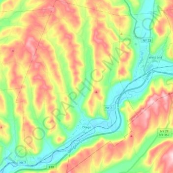
Name: Town of Otego topographic map, elevation, terrain.
Location: Town of Otego, Otsego County, New York, 13825, United States (42.35902 -75.25359 42.50289 -75.11528)
Average elevation: 1,486 ft
Minimum elevation: 1,030 ft
Maximum elevation: 2,129 ft
Otsego County trails, hiking, mountain biking, running and outdoor activities
Make a donation
Gear up for your next adventure:
As an Amazon Associate, this site earns from qualifying purchases at no extra cost to you.
Other topographic maps
Click on a map to view its topography, its elevation and its terrain.
Oneonta
United States > New York > Otsego County > City of Oneonta > Oneonta
Average elevation: 1,467 ft
South Hartwick
United States > New York > Otsego County > Town of Hartwick
Average elevation: 1,417 ft
Make a donation
Gear up for your next adventure:
As an Amazon Associate, this site earns from qualifying purchases at no extra cost to you.
Robinson Corners
United States > New York > Otsego County > Town of Edmeston
Average elevation: 1,398 ft
Maryland
United States > New York > Otsego County > Town of Maryland > Maryland
Average elevation: 1,522 ft
Make a donation
Gear up for your next adventure:
As an Amazon Associate, this site earns from qualifying purchases at no extra cost to you.