Geolocate

Lowell topographic map

Click on the map to display elevation.

About this map

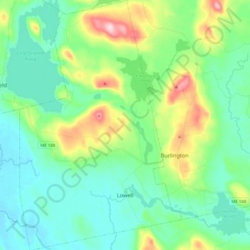
Name: Lowell topographic map, elevation, terrain.

Location: Lowell, Penobscot County, Maine, United States (45.15551 -68.55105 45.29667 -68.42103)

Average elevation: 308 ft

Minimum elevation: 121 ft

Maximum elevation: 863 ft

Penobscot County trails, hiking, mountain biking, running and outdoor activities

Other topographic maps

Click on a map to view its topography, its elevation and its terrain.

Lincoln

United States > Maine > Penobscot County > Lincoln

Average elevation: 272 ft

Houston Island

United States > Maine > Penobscot County > Winn

Average elevation: 243 ft

Carroll

United States > Maine > Penobscot County

Average elevation: 778 ft

Fairmont Park

United States > Maine > Penobscot County > Bangor

Average elevation: 148 ft

Meadow Brook

United States > Maine > Penobscot County

Average elevation: 325 ft

Gear up for your next adventure:

🧣Merino Neck Gaiters - Multi-functional headwear for wind and sun protection
💧Water Purification System - Clean water on the trail with reliable purifiers
📱Solar Portable Charger - Solar power bank for charging devices off‑grid
🩳Quick‑Dry Hiking Shorts - Comfortable and quick‑dry shorts for summer hiking
🪶Multi‑Purpose Knife - Useful blade for camp and trail

As an Amazon Associate, this site earns from qualifying purchases at no extra cost to you.