
Margaree Valley topographic map
Interactive map
Click on the map to display elevation.
About this map
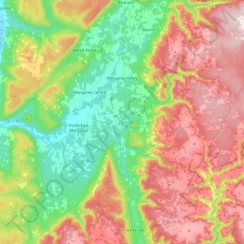
Name: Margaree Valley topographic map, elevation, terrain.
Average elevation: 732 ft
Minimum elevation: 0 ft
Maximum elevation: 1,608 ft
Other topographic maps
Click on a map to view its topography, its elevation and its terrain.
Glencoe
Canada > Nova Scotia > Municipality of the County of Inverness
Glencoe, Municipality of the County of Inverness, Inverness County, Nova Scotia, Canada
Average elevation: 518 ft
Broad Cove Chapel
Canada > Nova Scotia > Municipality of the County of Inverness
Broad Cove Chapel, Municipality of the County of Inverness, Inverness County, Nova Scotia, Canada
Average elevation: 276 ft
Marble Mountain
Canada > Nova Scotia > Municipality of the County of Inverness
Marble Mountain, Municipality of the County of Inverness, Inverness County, Nova Scotia, Canada
Average elevation: 180 ft
Big Harbour Island
Canada > Nova Scotia > Municipality of the County of Inverness
Big Harbour Island, Municipality of the County of Inverness, Inverness County, Nova Scotia, Canada
Average elevation: 10 ft
Margaree Forks
Canada > Nova Scotia > Municipality of the County of Inverness > Margaree Forks
Margaree Forks, Municipality of the County of Inverness, Inverness County, Nova Scotia, Canada
Average elevation: 440 ft
Margaree
Canada > Nova Scotia > Municipality of the County of Inverness > Margaree
Margaree, Municipality of the County of Inverness, Inverness County, Nova Scotia, Canada
Average elevation: 489 ft
Mabou
Canada > Nova Scotia > Municipality of the County of Inverness
Mabou, Municipality of the County of Inverness, Inverness County, Nova Scotia, Canada
Average elevation: 266 ft
Troy
Canada > Nova Scotia > Municipality of the County of Inverness
Troy, Municipality of the County of Inverness, Inverness County, Nova Scotia, Canada
Average elevation: 266 ft
Meat Cove
Canada > Nova Scotia > Municipality of the County of Inverness > Meat Cove
Meat Cove, Municipality of the County of Inverness, Inverness County, Nova Scotia, B0C 1E0, Canada
Average elevation: 696 ft