
Make a donation
Gear up for your next adventure:
As an Amazon Associate, this site earns from qualifying purchases at no extra cost to you.
Karoo National Park topographic map
Click on the map to display elevation.
Make a donation
Gear up for your next adventure:
As an Amazon Associate, this site earns from qualifying purchases at no extra cost to you.
About this map
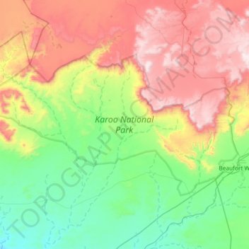
Name: Karoo National Park topographic map, elevation, terrain.
Average elevation: 3,671 ft
Minimum elevation: 2,133 ft
Maximum elevation: 6,421 ft
Make a donation
Gear up for your next adventure:
As an Amazon Associate, this site earns from qualifying purchases at no extra cost to you.
Other topographic maps
Click on a map to view its topography, its elevation and its terrain.
Karoo
South Africa > Western Cape > Central Karoo District Municipality > Beaufort West Local Municipality
The Karoo (/kəˈruə/ kə-ROO-ə; from the Afrikaans borrowing of the South Khoekhoe !Orakobab or Khoemana word ǃ’Aukarob "Hardveld") is a semi-desert natural region of South Africa. No exact definition of what constitutes the Karoo is available, so its extent is also not precisely defined. The Karoo is…
Average elevation: 2,890 ft
Prince Albert
South Africa > Western Cape > Central Karoo District Municipality > Prince Albert Local Municipality
Average elevation: 2,152 ft
Klaarstroom
South Africa > Western Cape > Central Karoo District Municipality > Prince Albert Local Municipality
Average elevation: 2,543 ft
Laingsburg
South Africa > Western Cape > Central Karoo District Municipality > Laingsburg Local Municipality
Average elevation: 2,306 ft
Make a donation
Gear up for your next adventure:
As an Amazon Associate, this site earns from qualifying purchases at no extra cost to you.
Beaufort West
South Africa > Western Cape > Central Karoo District Municipality > Beaufort West Local Municipality
Average elevation: 2,802 ft
Matjiesfontein
South Africa > Western Cape > Central Karoo District Municipality > Laingsburg Local Municipality
Average elevation: 3,189 ft
Gifberg
South Africa > Western Cape > Central Karoo District Municipality > Beaufort West Local Municipality
Average elevation: 4,016 ft
Seweweekspoortpiek
South Africa > Western Cape > Central Karoo District Municipality > Laingsburg Local Municipality
Average elevation: 5,801 ft
Make a donation
Gear up for your next adventure:
As an Amazon Associate, this site earns from qualifying purchases at no extra cost to you.
Cape Fold Mountains
South Africa > Western Cape > Central Karoo District Municipality > Prince Albert Local Municipality
The degree to which the original Cape Fold mountains (formed during the Carboniferous and early Permian Periods) have been eroded is attested to by the fact that the 1 km high Table Mountain on the Cape Peninsula is a syncline mountain, meaning that it formed part of the bottom of a valley when the Cape…
Average elevation: 4,656 ft
Murraysburg
South Africa > Western Cape > Central Karoo District Municipality > Beaufort West Local Municipality
Average elevation: 3,999 ft
Cape Fold Mountains
South Africa > Western Cape > Central Karoo District Municipality > Prince Albert Local Municipality
The degree to which the original Cape Fold mountains (formed during the Carboniferous and early Permian Periods) have been eroded is attested to by the fact that the 1 km high Table Mountain on the Cape Peninsula is a syncline mountain, meaning that it formed part of the bottom of a valley when the Cape…
Average elevation: 4,656 ft
Beaufort West
South Africa > Western Cape > Central Karoo District Municipality > Beaufort West Local Municipality
Average elevation: 2,802 ft
Make a donation
Gear up for your next adventure:
As an Amazon Associate, this site earns from qualifying purchases at no extra cost to you.
Great Karoo
South Africa > Western Cape > Central Karoo District Municipality > Beaufort West Local Municipality
Average elevation: 2,799 ft
Prince Albert
South Africa > Western Cape > Central Karoo District Municipality > Prince Albert Local Municipality
Average elevation: 2,152 ft
Beaufort West
South Africa > Western Cape > Central Karoo District Municipality > Beaufort West Local Municipality
Average elevation: 2,802 ft
Matjiesfontein
South Africa > Western Cape > Central Karoo District Municipality > Laingsburg Local Municipality
Average elevation: 3,189 ft
Make a donation
Gear up for your next adventure:
As an Amazon Associate, this site earns from qualifying purchases at no extra cost to you.
Murraysburg
South Africa > Western Cape > Central Karoo District Municipality > Beaufort West Local Municipality
Average elevation: 3,999 ft
Great Karoo
South Africa > Western Cape > Central Karoo District Municipality > Beaufort West Local Municipality
Average elevation: 2,799 ft
Laingsburg
South Africa > Western Cape > Central Karoo District Municipality > Laingsburg Local Municipality
Average elevation: 2,306 ft
Karoo
South Africa > Western Cape > Central Karoo District Municipality > Beaufort West Local Municipality
The Karoo (/kəˈruə/ kə-ROO-ə; from the Afrikaans borrowing of the South Khoekhoe Khoemana (also known as !Orakobab or Korana) word ǃ’Aukarob (Korana for 'Hardveld') is a semidesert natural region of South Africa. No exact definition of what constitutes the Karoo is available, so its extent is also not…
Average elevation: 2,890 ft
Make a donation
Gear up for your next adventure:
As an Amazon Associate, this site earns from qualifying purchases at no extra cost to you.