Geolocate

Jordan River topographic map

Click on the map to display elevation.

About this map

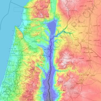
Name: Jordan River topographic map, elevation, terrain.

Location: Jordan River, Irbid, Jordan (31.75826 35.51891 33.19560 35.63096)

Average elevation: 1,201 ft

Minimum elevation: -1,362 ft

Maximum elevation: 4,009 ft

Other topographic maps

Click on a map to view its topography, its elevation and its terrain.

Al Mazar

Jordan > Irbid > Mazar Shamali Sub-District

Average elevation: 2,546 ft

Al-Turah

Jordan > Irbid > Ramtha Sub-District

Average elevation: 1,512 ft

Der Abi Saeed

Jordan > Irbid > Koorah Sub-District

Average elevation: 1,050 ft

Kufr Yuba

Jordan > Irbid

Average elevation: 1,791 ft

غرب اربد

Jordan > Irbid > Irbid Sub-District

Average elevation: 1,627 ft

Gear up for your next adventure:

🎒Hydration Pack - Hands‑free water reservoir for long hikes
🥄Camping Utensil Set - Lightweight utensils for outdoor meals
🛏️Cold Weather Sleeping Bag - Warm sleeping bag for cold conditions
🛠️Outdoor Gear Repair Kit - Essential tools to fix gear on the trail
🪄Magnetic Compass - Accurate compass for navigation

As an Amazon Associate, this site earns from qualifying purchases at no extra cost to you.