Geolocate

Edwardsville topographic map

Click on the map to display elevation.

About this map

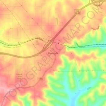
Name: Edwardsville topographic map, elevation, terrain.

Location: Edwardsville, Floyd County, Indiana, United States (38.26423 -85.92941 38.30423 -85.88941)

Average elevation: 817 ft

Minimum elevation: 518 ft

Maximum elevation: 1,004 ft

Floyd County trails, hiking, mountain biking, running and outdoor activities

Other topographic maps

Click on a map to view its topography, its elevation and its terrain.

Galena

United States > Indiana > Floyd County

Average elevation: 761 ft

Greenville

United States > Indiana > Floyd County

Average elevation: 804 ft

Gear up for your next adventure:

📱Solar Portable Charger - Solar power bank for charging devices off‑grid
🪶Thermal Camp Blanket - Extra warmth for cold nights
🌡️Handheld Weather Meters - Measure wind, temp, and pressure for safe mountain travel
🪶Paracord Bracelet - Survival bracelet with built‑in tools
👟Trail Running Shoes - Lightweight shoes for trail runners

As an Amazon Associate, this site earns from qualifying purchases at no extra cost to you.