
Taggerty topographic map
Click on the map to display elevation.
About this map
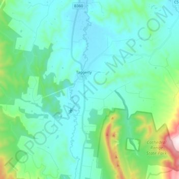
Name: Taggerty topographic map, elevation, terrain.
Location: Taggerty, Shire of Murrindindi, Victoria, 3714, Australia (-37.41839 145.63687 -37.27989 145.79915)
Average elevation: 1,325 ft
Minimum elevation: 627 ft
Maximum elevation: 3,862 ft
Other topographic maps
Click on a map to view its topography, its elevation and its terrain.
Ballarat
Ballarat has a moderate oceanic climate (Köppen climate classification Cfb) with four distinct seasons. Its elevation, ranging between 400 and 630 metres (1,310 and 2,070 feet) above sea level, causes its mean monthly temperatures to tend to be on average 3 to 5 °C (5 to 9 °F) below those of Melbourne,…
Average elevation: 1,542 ft
Melbourne
Melbourne is also prone to isolated convective showers forming when a cold pool crosses the state, especially if there is considerable daytime heating. These showers are often heavy and can include hail, squalls, and significant drops in temperature, but they often pass through very quickly with a rapid…
Average elevation: 161 ft
Mount Bogong
The Big River separates the massif of the mountain from the Bogong High Plains to the south. From the nearby town of Mount Beauty to its summit, Mount Bogong rises more than 1,600 metres (5,200 ft), thus making it one of the highest peaks in Australia not only in terms of its elevation above sea level, but…
Average elevation: 5,640 ft
Ballarat
Ballarat has a moderate oceanic climate (Köppen climate classification Cfb) with four distinct seasons. Its elevation, ranging between 400 and 630 metres (1,310 and 2,070 feet) above sea level, causes its mean monthly temperatures to tend to be on average 3 to 5 °C (5 to 9 °F) below those of Melbourne,…
Average elevation: 1,542 ft
Frankston
Australia > Victoria > Frankston
Olivers Hill is the most prominent elevation in Frankston which rises to 55 metres above sea level (180 feet) at its highest point in the suburb. Its origins date to approximately 415 to 360 million years ago. Its base is Mount Eliza Granite dating from the Devonian period, which was covered in lava tuffs in…
Average elevation: 118 ft
Buffalo Plateau
The summit of the highest peak of the plateau, known as The Horn, has an elevation of 1,723 metres (5,653 ft) AHD.
Average elevation: 4,928 ft