
Make a donation
Gear up for your next adventure:
As an Amazon Associate, this site earns from qualifying purchases at no extra cost to you.
Oldupai Gorge topographic map
Click on the map to display elevation.
Make a donation
Gear up for your next adventure:
As an Amazon Associate, this site earns from qualifying purchases at no extra cost to you.
About this map
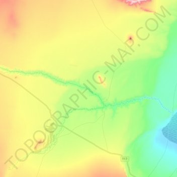
Name: Oldupai Gorge topographic map, elevation, terrain.
Location: Oldupai Gorge, Ngorongoro, Arusha, Northern Zone, Tanzania (-3.00000 35.22810 -2.94379 35.42896)
Average elevation: 4,902 ft
Minimum elevation: 4,265 ft
Maximum elevation: 5,846 ft
Make a donation
Gear up for your next adventure:
As an Amazon Associate, this site earns from qualifying purchases at no extra cost to you.
Other topographic maps
Click on a map to view its topography, its elevation and its terrain.
Arusha
Despite its proximity to the equator, Arusha's elevation of 1,400 metres (4,600 ft) on the southern slopes of Mount Meru keeps temperatures relatively low and alleviates humidity. Cool dry air is prevalent for much of the year. The temperature typically ranges between 10 and 30 °C (50 and 86 °F) with an…
Average elevation: 5,157 ft
Monduli
A number of isolated mountains (Monduli, Lepurko, Loosimingori, and Lengai) and broad rolling plains characterize the land landscape. The heights range from 600m in the low elevations to 2900m in the high elevations. The District's vegetation includes a combination of forest, bushland, woodland grassland, and…
Average elevation: 4,491 ft
Make a donation
Gear up for your next adventure:
As an Amazon Associate, this site earns from qualifying purchases at no extra cost to you.
Make a donation
Gear up for your next adventure:
As an Amazon Associate, this site earns from qualifying purchases at no extra cost to you.
Karatu
Karatu District (Wilaya ya Karatu, in Swahili) is one of seven districts of the Arusha Region of Tanzania. The district is bordered to the north by the Ngorongoro District and to the west by the Meatu District in the Simiyu Region. The district is bordered to the east by the Monduli District, and to the south…
Average elevation: 4,816 ft
Monduli
A number of isolated mountains (Monduli, Lepurko, Loosimingori, and Lengai) and broad rolling plains characterize the land landscape. The heights range from 600m in the low elevations to 2900m in the high elevations. The District's vegetation includes a combination of forest, bushland, woodland grassland, and…
Average elevation: 4,491 ft
Make a donation
Gear up for your next adventure:
As an Amazon Associate, this site earns from qualifying purchases at no extra cost to you.
Arusha
Despite its proximity to the equator, Arusha's elevation of 1,400 metres (4,600 ft) on the southern slopes of Mount Meru keeps temperatures relatively low and alleviates humidity. Cool dry air is prevalent for much of the year. The temperature typically ranges between 10 and 30 °C (50 and 86 °F) with an…
Average elevation: 5,157 ft
Make a donation
Gear up for your next adventure:
As an Amazon Associate, this site earns from qualifying purchases at no extra cost to you.
Make a donation
Gear up for your next adventure:
As an Amazon Associate, this site earns from qualifying purchases at no extra cost to you.