
Make a donation
Gear up for your next adventure:
As an Amazon Associate, this site earns from qualifying purchases at no extra cost to you.
Kecskéd topographic map
Click on the map to display elevation.
Make a donation
Gear up for your next adventure:
As an Amazon Associate, this site earns from qualifying purchases at no extra cost to you.
About this map
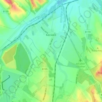
Name: Kecskéd topographic map, elevation, terrain.
Average elevation: 577 ft
Minimum elevation: 499 ft
Maximum elevation: 764 ft
Make a donation
Gear up for your next adventure:
As an Amazon Associate, this site earns from qualifying purchases at no extra cost to you.
Other topographic maps
Click on a map to view its topography, its elevation and its terrain.
Vértes
The area of the Vértes occupies 314 km2 (121 sq mi). It is about 30 km long and 10–15 km wide. The average altitude is above sea level is 350 meters; its highest points are 487 m (Nagy-Csákány), 480 m (Körtvélyes) and 479 m (Csóka-hegy). Geologically the Vértes constitute a fairly uniform structure.…
Average elevation: 804 ft