
Make a donation
Gear up for your next adventure:
As an Amazon Associate, this site earns from qualifying purchases at no extra cost to you.
Cordova Mines topographic map
Click on the map to display elevation.
Make a donation
Gear up for your next adventure:
As an Amazon Associate, this site earns from qualifying purchases at no extra cost to you.
About this map
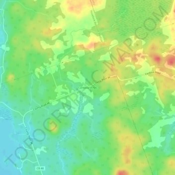
Name: Cordova Mines topographic map, elevation, terrain.
Average elevation: 686 ft
Minimum elevation: 610 ft
Maximum elevation: 784 ft
Make a donation
Gear up for your next adventure:
As an Amazon Associate, this site earns from qualifying purchases at no extra cost to you.
Other topographic maps
Click on a map to view its topography, its elevation and its terrain.
Cordova Lake
Canada > Ontario > Peterborough County > Havelock-Belmont-Methuen
Average elevation: 735 ft
Methuen Lake
Canada > Ontario > Peterborough County > Havelock-Belmont-Methuen
Average elevation: 961 ft
Make a donation
Gear up for your next adventure:
As an Amazon Associate, this site earns from qualifying purchases at no extra cost to you.