Geolocate

Dale topographic map

Click on the map to display elevation.

About this map

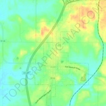
Name: Dale topographic map, elevation, terrain.

Location: Dale, Spencer County, Indiana, United States (38.15532 -87.00025 38.19223 -86.96400)

Average elevation: 453 ft

Minimum elevation: 400 ft

Maximum elevation: 525 ft

Spencer County trails, hiking, mountain biking, running and outdoor activities

Other topographic maps

Click on a map to view its topography, its elevation and its terrain.

Hatfield

United States > Indiana > Spencer County

Average elevation: 384 ft

Patronville

United States > Indiana > Spencer County

Average elevation: 427 ft

Rock Hill

United States > Indiana > Spencer County

Average elevation: 407 ft

Ritchie

United States > Indiana > Spencer County > Ritchie

Average elevation: 417 ft

Gear up for your next adventure:

🎒Gear Packing Cubes - Organize your backpack efficiently
🦶Hiking Gaiters - Keep debris and water out of your boots
🧭GPS Watch Accessories - Bands and chargers for GPS watches
🪑Portable Camp Table - Compact table for campsite meals
🌎3D Topographic Globes - Raised relief globes for a tactile understanding of geography

As an Amazon Associate, this site earns from qualifying purchases at no extra cost to you.