Geolocate

Kayanga topographic map

Click on the map to display elevation.

About this map

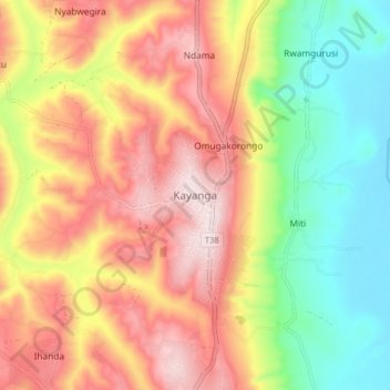
Name: Kayanga topographic map, elevation, terrain.

Location: Kayanga, Karagwe, Kagera, Lake Zone, Tanzania (-1.57027 31.11114 -1.49027 31.19114)

Average elevation: 4,656 ft

Minimum elevation: 3,852 ft

Maximum elevation: 5,459 ft

Other topographic maps

Click on a map to view its topography, its elevation and its terrain.

Muleba

Tanzania > Kagera

Average elevation: 4,121 ft

Bukoba

Tanzania > Kagera

Average elevation: 3,990 ft

Karagwe

Tanzania > Kagera

Average elevation: 4,442 ft

Kibeta

Tanzania > Kagera

Average elevation: 4,137 ft

Karagwe

Tanzania > Kagera

Average elevation: 4,442 ft

Karagwe

Tanzania > Kagera

Average elevation: 4,442 ft

Gear up for your next adventure:

🛰️Handheld GPS Units - Professional satellite navigators for precise backcountry mapping
🛰️Satellite Messengers - Emergency SOS and two-way messaging for off-grid adventures
🪶Fire Starter Kit - Reliable fire starter for survival and camping
🦟Ultrasonic Repellers - Create a bug-free zone at your camp or rest stop
👖Convertible Hiking Pants - Versatile zip-off pants for changing altitudes and temperatures

As an Amazon Associate, this site earns from qualifying purchases at no extra cost to you.