
Karagwe topographic map
Click on the map to display elevation.
About this map
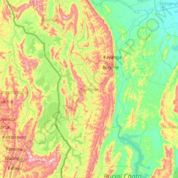
Name: Karagwe topographic map, elevation, terrain.
Location: Karagwe, Kagera, Lake Zone, Tanzania (-2.26065 30.80783 -1.18725 31.39287)
Average elevation: 4,442 ft
Minimum elevation: 3,747 ft
Maximum elevation: 6,240 ft
Other topographic maps
Click on a map to view its topography, its elevation and its terrain.
Bukoba
Bukoba has an upland tropical monsoon climate (Köppen Amb, because every month has a normal mean temperature of between 18 °C and 22 °C) although it is milder than most climates with that classification due to its altitude. It can sometimes get cool especially in the evenings during the two rainy seasons,…
Average elevation: 3,862 ft
Mutukula
The town of Mutukula is a border town between Uganda and Tanzania. At an altitude of 1,190 metres (3,900 ft), above sea level, Mutukula is an important border post and major crossing point, for both human and commercial traffic. In February 2016, the border post between both countries merged operations on both…
Average elevation: 3,875 ft