
Make a donation
Gear up for your next adventure:
As an Amazon Associate, this site earns from qualifying purchases at no extra cost to you.
Rio Verde topographic map
Click on the map to display elevation.
Make a donation
Gear up for your next adventure:
As an Amazon Associate, this site earns from qualifying purchases at no extra cost to you.
About this map
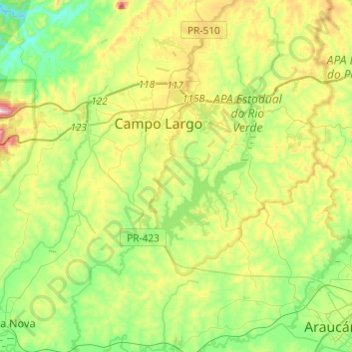
Name: Rio Verde topographic map, elevation, terrain.
Average elevation: 3,012 ft
Minimum elevation: 2,500 ft
Maximum elevation: 3,993 ft
Make a donation
Gear up for your next adventure:
As an Amazon Associate, this site earns from qualifying purchases at no extra cost to you.
Other topographic maps
Click on a map to view its topography, its elevation and its terrain.
Parque Newton Puppi
Brasil > Paraná > Região Metropolitana de Curitiba > Campo Largo
Average elevation: 3,077 ft
Morro do Ourives
Brasil > Paraná > Região Metropolitana de Curitiba > Campo Largo > Morro do Ourives
Average elevation: 2,982 ft
Morro do Cal
Brasil > Paraná > Região Metropolitana de Curitiba > Campo Largo
Average elevation: 3,054 ft