
Make a donation
Gear up for your next adventure:
As an Amazon Associate, this site earns from qualifying purchases at no extra cost to you.
Leimstruth topographic map
Click on the map to display elevation.
Make a donation
Gear up for your next adventure:
As an Amazon Associate, this site earns from qualifying purchases at no extra cost to you.
About this map
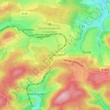
Name: Leimstruth topographic map, elevation, terrain.
Average elevation: 1,788 ft
Minimum elevation: 1,444 ft
Maximum elevation: 2,142 ft
Make a donation
Gear up for your next adventure:
As an Amazon Associate, this site earns from qualifying purchases at no extra cost to you.
Other topographic maps
Click on a map to view its topography, its elevation and its terrain.
Netphen
Deutschland > Nordrhein-Westfalen > Kreis Siegen-Wittgenstein
Große Teile des Netphener Stadtgebiets befinden sich im Rothaargebirge oder in den Siegerländer Rothaar-Vorhöhen. Höchste Berge im Stadtgebiet sind mit jeweils 676,5 m ü. NHN die Oberste Henn und mit 676,3 m ü. NHN der Jagdberg. Die meisten der hohen Berge im Netpherland befinden sich westlich und…
Average elevation: 1,302 ft
Siegen
Deutschland > Nordrhein-Westfalen > Kreis Siegen-Wittgenstein
Siegen ist die südlichste Stadt Westfalens bzw. des Siegerlands. Sie liegt in einem verzweigten Talkessel der oberen Sieg. Neben der Sieg sind die größten nennenswerten Fließgewässer innerhalb des Stadtgebiets die Sieg-Zuflüsse Ferndorf, Weiß, Alche, Eisernbach und Gosenbach. Vom Talkessel zweigen noch…
Average elevation: 1,135 ft
Wilnsdorf
Deutschland > Nordrhein-Westfalen > Kreis Siegen-Wittgenstein
Die Wilnsdorfer Orte im Weißtal gehörten bis auf Niederdielfen, Oberdielfen und Wilgersdorf (Amt Wilnsdorf) bis 1969 zum Amt Netphen. Die Weiß entspringt südlich des Ortsteils Wilgersdorf auf einer Höhe von 493 m. Nordöstlich von Wilgersdorf liegt mit Gernsdorf im Bichelbachtal, einem Seitental der…
Average elevation: 1,286 ft
Make a donation
Gear up for your next adventure:
As an Amazon Associate, this site earns from qualifying purchases at no extra cost to you.
Bad Berleburg
Deutschland > Nordrhein-Westfalen > Kreis Siegen-Wittgenstein
Etwa 23 Kilometer entfernt liegt die aus dem Wintersport bekannte Stadt Winterberg, welche ein ideales Ausflugsziel im Winter sowie im Sommer bietet. Ehemals gehörten die Höhendörfer Langewiese, Neuastenberg, Mollseifen und Hoheleye mit zum Amt Berleburg, dessen Orte ansonsten mit dem…
Average elevation: 1,788 ft
Freudenberg
Deutschland > Nordrhein-Westfalen > Kreis Siegen-Wittgenstein
Freudenberg liegt im historischen Siegerland in hügeliger Mittelgebirgslandschaft zwischen 243 und 505 m Höhe über dem Meeresspiegel. Die Landschaft gehört größtenteils zum Freudenberger Bergland, das wiederum Bestandteil des Naturraums Siegerland ist. Das südliche Stadtgebiet gehört zum Höhenzug…
Average elevation: 1,148 ft
Hilchenbach
Deutschland > Nordrhein-Westfalen > Kreis Siegen-Wittgenstein
Das größte Fließgewässer der Stadt ist der Ferndorfbach, ein Nebenfluss der Sieg. Die durchschnittliche Höhe des Stadtgebiets beträgt 427 m ü. NN, mit 677,7 m ü. NN bildet der Berg Riemen die höchste Erhebung im Stadtgebiet und im Siegerland.
Average elevation: 1,549 ft
Make a donation
Gear up for your next adventure:
As an Amazon Associate, this site earns from qualifying purchases at no extra cost to you.
Kreuztal
Deutschland > Nordrhein-Westfalen > Kreis Siegen-Wittgenstein
Der höchste Punkt der Stadt ist der „Hohe Wald“ in Burgholdinghausen mit 655 m ü. NN, der niedrigste Punkt befindet sich in Buschhütten. Dort verlässt die Ferndorf auf einer Höhe von 260 m ü. NN das Stadtgebiet. Die Nord-Süd-Ausdehnung beträgt 12 km, die Ost-West-Ausdehnung 11 Kilometer.
Average elevation: 1,339 ft
Burgholdinghausen
Deutschland > Nordrhein-Westfalen > Kreis Siegen-Wittgenstein > Kreuztal
Average elevation: 1,493 ft
Niederndorf
Deutschland > Nordrhein-Westfalen > Kreis Siegen-Wittgenstein > Freudenberg
Average elevation: 1,030 ft
Erndtebrück
Deutschland > Nordrhein-Westfalen > Kreis Siegen-Wittgenstein
Mit seiner Höhe von etwa 500 m und seiner geographischen Lage am Südwestrand des Rothaargebirges weist Erndtebrück ein recht raues und kühles Klima auf. Vor allem in klaren und windstillen Nächten kann die Temperatur hier im oberen Edertal stark absinken. Allein im Winter 2009/10 unterschritt sie viermal…
Average elevation: 1,781 ft
Make a donation
Gear up for your next adventure:
As an Amazon Associate, this site earns from qualifying purchases at no extra cost to you.
Eiserfeld
Deutschland > Nordrhein-Westfalen > Kreis Siegen-Wittgenstein > Siegen
Der Ort Eiserfeld liegt verteilt in mehreren Tälern auf einer Höhe zwischen 220 und 370 m und ist damit neben Niederschelden der am tiefsten liegende Ort im Kreisgebiet. Der größte Teil liegt am Mündungsende des Tales des Eisernbachs, der im Ort auf ca. 220 m Höhe in die Sieg mündet. Im Nordwesten macht…
Average elevation: 1,089 ft
Büschergrund
Deutschland > Nordrhein-Westfalen > Kreis Siegen-Wittgenstein > Freudenberg
Büschergrund liegt im oberen Talende der Weibe auf einer Höhe zwischen 290 und 360 m ü. NN.
Average elevation: 1,230 ft
Meiswinkel
Deutschland > Nordrhein-Westfalen > Kreis Siegen-Wittgenstein > Siegen
Meiswinkel ist ein landwirtschaftlich geprägter Stadtteil im Norden Siegens. Der Ort liegt im Talende des Birlenbachs, der im Ort entspringt und hier auch Meiswinkelbach genannt wird. Er fließt südöstlich in Richtung Langenholdinghausen. Südwestlich liegt ebenfalls ein kleines Tal, das allerdings kaum…
Average elevation: 1,217 ft
Oberfischbach
Deutschland > Nordrhein-Westfalen > Kreis Siegen-Wittgenstein > Freudenberg
Average elevation: 1,060 ft
Make a donation
Gear up for your next adventure:
As an Amazon Associate, this site earns from qualifying purchases at no extra cost to you.
57072
Deutschland > Nordrhein-Westfalen > Kreis Siegen-Wittgenstein > Siegen > Trupbach
Average elevation: 1,053 ft
Dillnhütten
Deutschland > Nordrhein-Westfalen > Kreis Siegen-Wittgenstein > Siegen
Average elevation: 997 ft
57299
Deutschland > Nordrhein-Westfalen > Kreis Siegen-Wittgenstein > Burbach
Average elevation: 1,549 ft
Müsen
Deutschland > Nordrhein-Westfalen > Kreis Siegen-Wittgenstein > Hilchenbach
Müsen liegt oberhalb von Hilchenbach-Dahlbruch im nördlichen Siegerland. Der Ort liegt auf ca. 340 m im Rothenbachtal, einer nach Süden geöffneten Mulde, zwischen der Martinshardt mit 616,1 m Höhe, dem Kindelsberg mit 617,9 m Höhe, dem Ziegenberg mit 521 m Höhe und dem Breitenberg mit 529 m Höhe.…
Average elevation: 1,440 ft
Make a donation
Gear up for your next adventure:
As an Amazon Associate, this site earns from qualifying purchases at no extra cost to you.
Unglinghausen
Deutschland > Nordrhein-Westfalen > Kreis Siegen-Wittgenstein > Netphen
Average elevation: 1,217 ft
Oelgershausen
Deutschland > Nordrhein-Westfalen > Kreis Siegen-Wittgenstein > Netphen
Average elevation: 1,148 ft
Grissenbach
Deutschland > Nordrhein-Westfalen > Kreis Siegen-Wittgenstein > Netphen
Average elevation: 1,342 ft
57078
Deutschland > Nordrhein-Westfalen > Kreis Siegen-Wittgenstein > Siegen
Average elevation: 997 ft
Make a donation
Gear up for your next adventure:
As an Amazon Associate, this site earns from qualifying purchases at no extra cost to you.
Obersetzen
Deutschland > Nordrhein-Westfalen > Kreis Siegen-Wittgenstein > Siegen
Average elevation: 1,184 ft
57234
Deutschland > Nordrhein-Westfalen > Kreis Siegen-Wittgenstein > Wilnsdorf
Average elevation: 1,319 ft
Salchendorf
Deutschland > Nordrhein-Westfalen > Kreis Siegen-Wittgenstein > Netphen
Die Bebauung des Orts befindet sich auf einer Höhe zwischen 330 und 390 m ü. NHN. Die Gemarkung Salchendorf hat eine Fläche von 9,2 km². Berge und Erhebungen um Salchendorf sind unter anderem Heinenberg 530,7 m, Rübenhain, Auf der Noll mit 474,1 m und der Haferhain mit 503,5 m Höhe. Durch den Ort fließt…
Average elevation: 1,322 ft
Dahlbruch
Deutschland > Nordrhein-Westfalen > Kreis Siegen-Wittgenstein > Hilchenbach
Average elevation: 1,207 ft
Make a donation
Gear up for your next adventure:
As an Amazon Associate, this site earns from qualifying purchases at no extra cost to you.
Anzhausen
Deutschland > Nordrhein-Westfalen > Kreis Siegen-Wittgenstein > Wilnsdorf
Average elevation: 1,207 ft
Ferndorf
Deutschland > Nordrhein-Westfalen > Kreis Siegen-Wittgenstein > Kreuztal
Average elevation: 1,227 ft
Werthenbach
Deutschland > Nordrhein-Westfalen > Kreis Siegen-Wittgenstein > Netphen
Average elevation: 1,604 ft
Feuersbach
Deutschland > Nordrhein-Westfalen > Kreis Siegen-Wittgenstein > Siegen
Average elevation: 1,217 ft
Make a donation
Gear up for your next adventure:
As an Amazon Associate, this site earns from qualifying purchases at no extra cost to you.
57271
Deutschland > Nordrhein-Westfalen > Kreis Siegen-Wittgenstein > Hilchenbach
Average elevation: 1,365 ft
57076
Deutschland > Nordrhein-Westfalen > Kreis Siegen-Wittgenstein > Siegen
Average elevation: 1,001 ft
Helgersdorf
Deutschland > Nordrhein-Westfalen > Kreis Siegen-Wittgenstein > Netphen
Average elevation: 1,358 ft
57334
Deutschland > Nordrhein-Westfalen > Kreis Siegen-Wittgenstein > Bad Laasphe > Banfe
Average elevation: 1,640 ft
Make a donation
Gear up for your next adventure:
As an Amazon Associate, this site earns from qualifying purchases at no extra cost to you.
Eichen
Deutschland > Nordrhein-Westfalen > Kreis Siegen-Wittgenstein > Kreuztal
Average elevation: 1,171 ft
Holunderweg
Deutschland > Nordrhein-Westfalen > Kreis Siegen-Wittgenstein > Siegen
Average elevation: 1,024 ft
Gosenbach
Deutschland > Nordrhein-Westfalen > Kreis Siegen-Wittgenstein > Siegen > Oberschelden
Der niedrigste Punkt befindet sich am Talausgang des Gosenbachs an der Grenze zu Niederschelden und hat eine Höhe von 236 m ü. NN. Der höchste Punkt ist der Gipfel der Roten Kirche und hat eine Höhe von 439 m ü. NN. Die Niederschlagsmenge beträgt etwa 1.000 mm pro Jahr.
Average elevation: 1,102 ft
Buschhütten
Deutschland > Nordrhein-Westfalen > Kreis Siegen-Wittgenstein > Kreuztal
Average elevation: 1,060 ft
Make a donation
Gear up for your next adventure:
As an Amazon Associate, this site earns from qualifying purchases at no extra cost to you.
Nenkersdorf
Deutschland > Nordrhein-Westfalen > Kreis Siegen-Wittgenstein > Netphen > Nenkersdorf
Average elevation: 1,594 ft
Littfeld
Deutschland > Nordrhein-Westfalen > Kreis Siegen-Wittgenstein > Kreuztal
Typische Häuser stellen das Fachwerk- und das geschieferte Haus dar. Allen alten Gebäuden eigen ist die überwiegende Traufständigkeit zur Straße, ebenso eine relativ einheitliche Höhe der Traufe, was auf die vorherrschende Dreigeschossigkeit der Gebäude zurückzuführen ist. Bei der Gestaltung der…
Average elevation: 1,365 ft
Sohlbach
Deutschland > Nordrhein-Westfalen > Kreis Siegen-Wittgenstein > Netphen > Sohlbach
Average elevation: 1,611 ft
Eisern
Deutschland > Nordrhein-Westfalen > Kreis Siegen-Wittgenstein > Siegen
Average elevation: 1,211 ft
Make a donation
Gear up for your next adventure:
As an Amazon Associate, this site earns from qualifying purchases at no extra cost to you.
Neunkirchen
Deutschland > Nordrhein-Westfalen > Kreis Siegen-Wittgenstein
Vorwiegend durch südwestliche bis nordwestliche Winde und die Höhenlage wird das Klima im Gebiet bestimmt. Durch häufige starke Bewölkung ergeben sich hohe Niederschlagsmengen (für die Gemeinde Neunkirchen etwa 1000 mm/Jahr) und recht niedrige Temperaturen (für Neunkirchen zwischen 7,0 und 7,7 °C im…
Average elevation: 1,220 ft
Breitenbach
Deutschland > Nordrhein-Westfalen > Kreis Siegen-Wittgenstein > Siegen
Average elevation: 1,286 ft
57319
Deutschland > Nordrhein-Westfalen > Kreis Siegen-Wittgenstein > Bad Berleburg
Average elevation: 1,588 ft
Niederschelden
Deutschland > Nordrhein-Westfalen > Kreis Siegen-Wittgenstein > Siegen
Average elevation: 1,027 ft
Make a donation
Gear up for your next adventure:
As an Amazon Associate, this site earns from qualifying purchases at no extra cost to you.
Oberes Schloss
Deutschland > Nordrhein-Westfalen > Kreis Siegen-Wittgenstein > Siegen
Das Obere Schloss liegt auf dem 307 m hohen Siegberg in der Stadt Siegen. Die Anlage geht auf eine mittelalterliche Höhenburg zurück, die anfangs in gemeinschaftlichem Besitz der Erzbischöfe von Köln und der Grafen von Nassau war. Später ging sie ganz in nassauischen Besitz über. Teilweise umgebaut…
Average elevation: 928 ft
Schloß Wittgenstein
Deutschland > Nordrhein-Westfalen > Kreis Siegen-Wittgenstein > Bad Laasphe > Laaspherhütte
Average elevation: 1,309 ft
Kreuztal
Deutschland > Nordrhein-Westfalen > Kreis Siegen-Wittgenstein
Der höchste Punkt der Stadt ist der „Hohe Wald“ in Burgholdinghausen mit 655 m ü. NN, der niedrigste Punkt befindet sich in Buschhütten. Dort verlässt der Ferndorfbach auf einer Höhe von 260 m ü. NN das Stadtgebiet. Die Nord-Süd-Ausdehnung beträgt 12 km, die Ost-West-Ausdehnung 11 Kilometer.
Average elevation: 1,339 ft
Dahlbruch
Deutschland > Nordrhein-Westfalen > Kreis Siegen-Wittgenstein > Hilchenbach
Average elevation: 1,204 ft
Make a donation
Gear up for your next adventure:
As an Amazon Associate, this site earns from qualifying purchases at no extra cost to you.
Erndtebrück
Deutschland > Nordrhein-Westfalen > Kreis Siegen-Wittgenstein
Mit seiner Höhe von etwa 500 m und seiner geographischen Lage am Südwestrand des Rothaargebirges weist Erndtebrück ein recht raues und kühles Klima auf. Vor allem in klaren und windstillen Nächten kann die Temperatur hier im oberen Edertal stark absinken. Allein im Winter 2009/10 unterschritt sie viermal…
Average elevation: 1,781 ft
Bad Berleburg
Deutschland > Nordrhein-Westfalen > Kreis Siegen-Wittgenstein
Etwa 23 Kilometer entfernt liegt die aus dem Wintersport bekannte Stadt Winterberg. Ehemals gehörten die Höhendörfer Langewiese, Neuastenberg, Mollseifen und Hoheleye mit zum Amt Berleburg, dessen Orte ansonsten mit dem Sauerland-Paderborn-Gesetz vom November 1974 größtenteils an die Stadt Bad Berleburg…
Average elevation: 1,788 ft
Dahlbruch
Deutschland > Nordrhein-Westfalen > Kreis Siegen-Wittgenstein > Hilchenbach
Average elevation: 1,204 ft
Netphen
Deutschland > Nordrhein-Westfalen > Kreis Siegen-Wittgenstein
Große Teile des Netphener Stadtgebiets befinden sich im Rothaargebirge oder in den Siegerländer Rothaar-Vorhöhen. Höchste Berge im Stadtgebiet sind mit jeweils 676,5 m ü. NHN die Oberste Henn und mit 676,3 m ü. NHN der Jagdberg. Die meisten der hohen Berge im Netpherland befinden sich westlich und…
Average elevation: 1,302 ft
Make a donation
Gear up for your next adventure:
As an Amazon Associate, this site earns from qualifying purchases at no extra cost to you.
Hilchenbach
Deutschland > Nordrhein-Westfalen > Kreis Siegen-Wittgenstein
Das größte Fließgewässer der Stadt ist die Ferndorf, ein Nebenfluss und hydrologisches Quellgewässer der Sieg. Die durchschnittliche Höhe des Stadtgebiets beträgt 427 m ü. NN, mit 677,7 m ü. NN bildet der Berg Riemen die höchste Erhebung im Stadtgebiet und im Siegerland.
Average elevation: 1,549 ft
Krombach
Deutschland > Nordrhein-Westfalen > Kreis Siegen-Wittgenstein > Kreuztal
Im Zuge des Weiterbaus der Bundesautobahn 4 und der Hüttentalstraße, die sich auf der „Krombacher Höhe“ (Kölsches Heck) treffen, erlangt der Ortsteil Krombach eine größere Bedeutung für das Siegerland und das angrenzende Sauerland. Seit 1935 existiert in Krombach ein Naturfreibad.
Average elevation: 1,247 ft
Gosenbach
Deutschland > Nordrhein-Westfalen > Kreis Siegen-Wittgenstein > Siegen > Oberschelden
Der niedrigste Punkt befindet sich am Talausgang des Gosenbachs an der Grenze zu Niederschelden und hat eine Höhe von 236 m ü. NN. Der höchste Punkt ist der Gipfel der Roten Kirche und hat eine Höhe von 439 m ü. NN. Die Niederschlagsmenge beträgt etwa 1.000 mm pro Jahr.
Average elevation: 1,102 ft
Bad Berleburg
Deutschland > Nordrhein-Westfalen > Kreis Siegen-Wittgenstein
Etwa 23 Kilometer entfernt liegt die aus dem Wintersport bekannte Stadt Winterberg. Ehemals gehörten die Höhendörfer Langewiese, Neuastenberg, Mollseifen und Hoheleye mit zum Amt Berleburg, dessen Orte ansonsten mit dem Sauerland/Paderborn-Gesetz vom November 1974 größtenteils an die Stadt Bad Berleburg…
Average elevation: 1,788 ft
Make a donation
Gear up for your next adventure:
As an Amazon Associate, this site earns from qualifying purchases at no extra cost to you.
Bad Berleburg
Deutschland > Nordrhein-Westfalen > Kreis Siegen-Wittgenstein
Etwa 23 Kilometer entfernt liegt die aus dem Wintersport bekannte Stadt Winterberg, welche ein ideales Ausflugsziel im Winter sowie im Sommer bietet. Ehemals gehörten die Höhendörfer Langewiese, Neuastenberg, Mollseifen und Hoheleye mit zum Amt Berleburg, dessen Orte ansonsten mit dem…
Average elevation: 1,788 ft