
Make a donation
Gear up for your next adventure:
As an Amazon Associate, this site earns from qualifying purchases at no extra cost to you.
Vilarinho topographic map
Click on the map to display elevation.
Make a donation
Gear up for your next adventure:
As an Amazon Associate, this site earns from qualifying purchases at no extra cost to you.
About this map
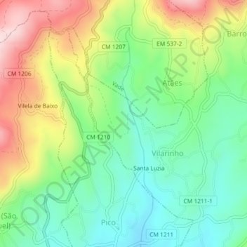
Name: Vilarinho topographic map, elevation, terrain.
Average elevation: 653 ft
Minimum elevation: 249 ft
Maximum elevation: 1,306 ft
Make a donation
Gear up for your next adventure:
As an Amazon Associate, this site earns from qualifying purchases at no extra cost to you.
Other topographic maps
Click on a map to view its topography, its elevation and its terrain.
Monte da Cheira
Portugal > Braga > Vila Verde > Prado (São Miguel) > Prado (São Miguel)
Average elevation: 1,161 ft
Godinhaços
Portugal > Braga > Vila Verde
Nesta freguesia encontra-se a nascente do Rio Neiva, a uma altitude de 654 metros, na Serra de Oural.
Average elevation: 1,398 ft
Make a donation
Gear up for your next adventure:
As an Amazon Associate, this site earns from qualifying purchases at no extra cost to you.
Make a donation
Gear up for your next adventure:
As an Amazon Associate, this site earns from qualifying purchases at no extra cost to you.
Monte do Borrelho
Portugal > Braga > Vila Verde > Pico de Regalados, Gondiães e Mós
Average elevation: 1,161 ft
Make a donation
Gear up for your next adventure:
As an Amazon Associate, this site earns from qualifying purchases at no extra cost to you.
Make a donation
Gear up for your next adventure:
As an Amazon Associate, this site earns from qualifying purchases at no extra cost to you.
Barbudo
Portugal > Braga > Vila Verde
O nome de Barbudo deve ter por origem a palavra barbeito do latim vervactum, que é uma pequena elevação de terreno, que divide uma propriedade de outra e a resguarda em referência ao castro do monte do Castelo. A paróquia de Barbudo em 1758 denominava-se, Parada e Barbudo , estava anexada há mais de dois…
Average elevation: 410 ft
Make a donation
Gear up for your next adventure:
As an Amazon Associate, this site earns from qualifying purchases at no extra cost to you.
Make a donation
Gear up for your next adventure:
As an Amazon Associate, this site earns from qualifying purchases at no extra cost to you.
Lagoa de Gondiães
Portugal > Braga > Vila Verde > Pico de Regalados, Gondiães e Mós
Average elevation: 1,148 ft
Make a donation
Gear up for your next adventure:
As an Amazon Associate, this site earns from qualifying purchases at no extra cost to you.
Make a donation
Gear up for your next adventure:
As an Amazon Associate, this site earns from qualifying purchases at no extra cost to you.