
Make a donation
Gear up for your next adventure:
As an Amazon Associate, this site earns from qualifying purchases at no extra cost to you.
Woodeaton topographic map
Click on the map to display elevation.
Make a donation
Gear up for your next adventure:
As an Amazon Associate, this site earns from qualifying purchases at no extra cost to you.
About this map
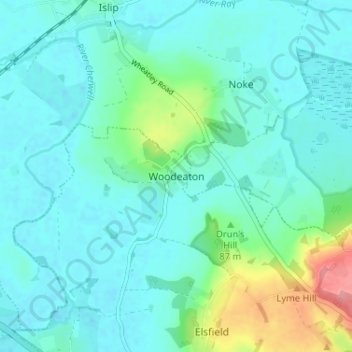
Name: Woodeaton topographic map, elevation, terrain.
Average elevation: 236 ft
Minimum elevation: 180 ft
Maximum elevation: 463 ft
Make a donation
Gear up for your next adventure:
As an Amazon Associate, this site earns from qualifying purchases at no extra cost to you.
Other topographic maps
Click on a map to view its topography, its elevation and its terrain.
Clifton Hampden
United Kingdom > England > Oxfordshire > South Oxfordshire > Clifton Hampden
Average elevation: 190 ft
Make a donation
Gear up for your next adventure:
As an Amazon Associate, this site earns from qualifying purchases at no extra cost to you.
Harpsden Wood
United Kingdom > England > Oxfordshire > South Oxfordshire > Henley-on-Thames > Harpsden
Average elevation: 207 ft
Watlington Hill
United Kingdom > England > Oxfordshire > South Oxfordshire > Watlington
Average elevation: 620 ft
Kingwood Common
United Kingdom > England > Oxfordshire > South Oxfordshire > Highmoor
Average elevation: 410 ft
Make a donation
Gear up for your next adventure:
As an Amazon Associate, this site earns from qualifying purchases at no extra cost to you.
Goring-on-Thames
United Kingdom > England > Oxfordshire > South Oxfordshire > Goring-on-Thames
Average elevation: 285 ft
Cowleaze Wood
United Kingdom > England > Oxfordshire > South Oxfordshire > Lewknor
Average elevation: 686 ft
Make a donation
Gear up for your next adventure:
As an Amazon Associate, this site earns from qualifying purchases at no extra cost to you.
Sonning Eye
United Kingdom > England > Oxfordshire > South Oxfordshire > Dunsden Green > Sonning Eye
Average elevation: 144 ft
Sandford-on-Thames
United Kingdom > England > Oxfordshire > South Oxfordshire
Average elevation: 223 ft
Make a donation
Gear up for your next adventure:
As an Amazon Associate, this site earns from qualifying purchases at no extra cost to you.
Make a donation
Gear up for your next adventure:
As an Amazon Associate, this site earns from qualifying purchases at no extra cost to you.
Drayton St. Leonard
United Kingdom > England > Oxfordshire > South Oxfordshire
Average elevation: 177 ft
Brightwell-cum-Sotwell
United Kingdom > England > Oxfordshire > South Oxfordshire
Average elevation: 177 ft
Make a donation
Gear up for your next adventure:
As an Amazon Associate, this site earns from qualifying purchases at no extra cost to you.
Pill Pond
United Kingdom > England > Oxfordshire > South Oxfordshire > Didcot
Average elevation: 233 ft
Nuneham Courtenay
United Kingdom > England > Oxfordshire > South Oxfordshire
Average elevation: 226 ft
Make a donation
Gear up for your next adventure:
As an Amazon Associate, this site earns from qualifying purchases at no extra cost to you.
Make a donation
Gear up for your next adventure:
As an Amazon Associate, this site earns from qualifying purchases at no extra cost to you.
Kidmore End
United Kingdom > England > Oxfordshire > South Oxfordshire > Kidmore End
Average elevation: 308 ft
Horspath
United Kingdom > England > Oxfordshire > South Oxfordshire > Horspath
Average elevation: 344 ft
Make a donation
Gear up for your next adventure:
As an Amazon Associate, this site earns from qualifying purchases at no extra cost to you.
Chinnor Quarry 2B
United Kingdom > England > Oxfordshire > South Oxfordshire > Kingston Blount > Crowell
Average elevation: 535 ft
Whitchurch-on-Thames
United Kingdom > England > Oxfordshire > South Oxfordshire > Whitchurch-on-Thames
Average elevation: 276 ft
Make a donation
Gear up for your next adventure:
As an Amazon Associate, this site earns from qualifying purchases at no extra cost to you.
Edmonds Park
United Kingdom > England > Oxfordshire > South Oxfordshire > Didcot > East Hagbourne
Average elevation: 223 ft
Rotherfield Peppard
United Kingdom > England > Oxfordshire > South Oxfordshire > Rotherfield Peppard
Average elevation: 377 ft
Make a donation
Gear up for your next adventure:
As an Amazon Associate, this site earns from qualifying purchases at no extra cost to you.
Shirburn
United Kingdom > England > Oxfordshire > South Oxfordshire
Shirburn is a village and civil parish about 6 miles (10 km) south of Thame in Oxfordshire. It contains the Grade I listed, 14th-century Shirburn Castle, along with its surrounding, Grade II listed park, and a parish church, the oldest part of which is from the Norman period. The parish has a high altitude by…
Average elevation: 459 ft
Make a donation
Gear up for your next adventure:
As an Amazon Associate, this site earns from qualifying purchases at no extra cost to you.
Brightwell Baldwin
United Kingdom > England > Oxfordshire > South Oxfordshire > Cuxham
Average elevation: 318 ft
Sonning Common
United Kingdom > England > Oxfordshire > South Oxfordshire > Sonning Common
Average elevation: 289 ft
Make a donation
Gear up for your next adventure:
As an Amazon Associate, this site earns from qualifying purchases at no extra cost to you.
Make a donation
Gear up for your next adventure:
As an Amazon Associate, this site earns from qualifying purchases at no extra cost to you.
East Hagbourne
United Kingdom > England > Oxfordshire > South Oxfordshire > East Hagbourne
Average elevation: 203 ft
Make a donation
Gear up for your next adventure:
As an Amazon Associate, this site earns from qualifying purchases at no extra cost to you.
Stanton St John
United Kingdom > England > Oxfordshire > South Oxfordshire > Stanton St John
Average elevation: 282 ft
Make a donation
Gear up for your next adventure:
As an Amazon Associate, this site earns from qualifying purchases at no extra cost to you.
Make a donation
Gear up for your next adventure:
As an Amazon Associate, this site earns from qualifying purchases at no extra cost to you.
Swyncombe
United Kingdom > England > Oxfordshire > South Oxfordshire > Swyncombe
Average elevation: 571 ft
Aston Rowant Nature Reserve
United Kingdom > England > Oxfordshire > South Oxfordshire > Lewknor
Average elevation: 630 ft
Make a donation
Gear up for your next adventure:
As an Amazon Associate, this site earns from qualifying purchases at no extra cost to you.
Warborough
United Kingdom > England > Oxfordshire > South Oxfordshire > Warborough
Average elevation: 174 ft
Drayton St. Leonard
United Kingdom > England > Oxfordshire > South Oxfordshire
Average elevation: 177 ft
Make a donation
Gear up for your next adventure:
As an Amazon Associate, this site earns from qualifying purchases at no extra cost to you.
Holly Wood
United Kingdom > England > Oxfordshire > South Oxfordshire > Stanton St John
Average elevation: 262 ft
Make a donation
Gear up for your next adventure:
As an Amazon Associate, this site earns from qualifying purchases at no extra cost to you.