Geolocate

Montreal topographic map

Click on the map to display elevation.

About this map

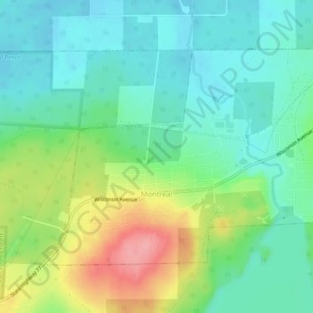
Name: Montreal topographic map, elevation, terrain.

Location: Montreal, Iron County, Wisconsin, United States (46.42057 -90.26314 46.44324 -90.21564)

Average elevation: 1,522 ft

Minimum elevation: 1,411 ft

Maximum elevation: 1,762 ft

Iron County trails, hiking, mountain biking, running and outdoor activities

Other topographic maps

Click on a map to view its topography, its elevation and its terrain.

Powell

United States > Wisconsin > Iron County

Average elevation: 1,598 ft

Saxon

United States > Wisconsin > Iron County

Average elevation: 1,112 ft

Iron Belt

United States > Wisconsin > Iron County

Average elevation: 1,558 ft

Payment Lake

United States > Wisconsin > Iron County > Town of Mercer

Average elevation: 1,624 ft

Gear up for your next adventure:

👖Convertible Hiking Pants - Versatile zip-off pants for changing altitudes and temperatures
🧯Portable Fire Pit - Compact fire pit for camping spots
🌄Hiking Binoculars - Compact binoculars for scenic views and trail spotting
🪑Ultralight Camp Chairs - Portable seating for resting after a long day of mapping
Solar GPS Watches - Advanced multisport watches with built-in topographic maps

As an Amazon Associate, this site earns from qualifying purchases at no extra cost to you.