
Piringen topographic map
Click on the map to display elevation.
Piringen
Piringen ligt in vochtig-Haspengouw, op een hoogte van 65 tot 107 meter. Ten noorden van Piringen begint een beekje dat uitmondt in de Fonteinbeek. De vallei hiervan, met de steilrand naar de Ganzenberg, is aangewezen als natuurgebied. Het is vochtig en heeft een bijzondere flora en fauna. Op het plateau, dat doorsneden wordt door holle wegen, wordt landbouw en fruitteelt beoefend.
About this map
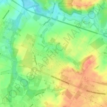
Name: Piringen topographic map, elevation, terrain.
Location: Piringen, Tongeren, Limburg, België (50.77498 5.40156 50.79898 5.43866)
Average elevation: 276 ft
Minimum elevation: 194 ft
Maximum elevation: 361 ft
Other topographic maps
Click on a map to view its topography, its elevation and its terrain.
Offelken
België > Limburg > Tongeren > Tongeren
Offelken ligt in Droog-Haspengouw. De hoogte varieert tussen 88 en 98 meter. De kern van het gehucht ligt ten zuiden van de aftakking van de Oude Jeker. Deze waterloop werd aangelegd door de mens en heeft een lengte van ongeveer drie kilometer.
Average elevation: 315 ft