Geolocate

Ullensaker topographic map

Click on the map to display elevation.

About this map

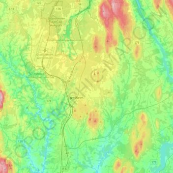
Name: Ullensaker topographic map, elevation, terrain.

Location: Ullensaker, Viken, Norway (60.05161 11.04086 60.25657 11.33572)

Average elevation: 594 ft

Minimum elevation: 341 ft

Maximum elevation: 1,152 ft

Other topographic maps

Click on a map to view its topography, its elevation and its terrain.

Ribba

Norway > Viken

Average elevation: 16 ft

Land

Norway > Viken

Average elevation: 709 ft

Sandvika

Norway > Viken

Average elevation: 197 ft

Engelsviken

Norway > Viken > Engelsviken

Average elevation: 39 ft

Gear up for your next adventure:

GPS Sports Watch - GPS watch for running, hiking and training
📦Gear Storage Bags - Organize and protect outdoor equipment
🧤Tactile Hiking Gloves - Keep hands warm while operating GPS and smartphone screens
🎒Trail Energy Bars - High‑calorie bars for hiking energy
🚁Photography Drones - Capture stunning aerial views of landforms and topography

As an Amazon Associate, this site earns from qualifying purchases at no extra cost to you.