
Make a donation
Gear up for your next adventure:
As an Amazon Associate, this site earns from qualifying purchases at no extra cost to you.
Lake City topographic map
Click on the map to display elevation.
Make a donation
Gear up for your next adventure:
As an Amazon Associate, this site earns from qualifying purchases at no extra cost to you.
Lake City
Lake City experiences a continental climate (Köppen climate classification Dfb) that only just escapes being classified as semi-arid due to its relatively wet early springs and late autumns. On average, the wettest month is August, and the driest is February. Very large daily temperature swings are a regular feature of Lake City's climate, due to the elevation and aridity.
Make a donation
Gear up for your next adventure:
As an Amazon Associate, this site earns from qualifying purchases at no extra cost to you.
About this map
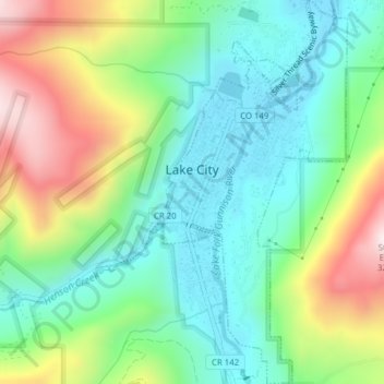
Name: Lake City topographic map, elevation, terrain.
Location: Lake City, Hinsdale County, Colorado, United States (38.01338 -107.32000 38.04394 -107.30126)
Average elevation: 9,298 ft
Minimum elevation: 8,629 ft
Maximum elevation: 10,610 ft
Hinsdale County trails, hiking, mountain biking, running and outdoor activities
Make a donation
Gear up for your next adventure:
As an Amazon Associate, this site earns from qualifying purchases at no extra cost to you.
Other topographic maps
Click on a map to view its topography, its elevation and its terrain.
Make a donation
Gear up for your next adventure:
As an Amazon Associate, this site earns from qualifying purchases at no extra cost to you.