
Make a donation
Gear up for your next adventure:
As an Amazon Associate, this site earns from qualifying purchases at no extra cost to you.
Handies Peak topographic map
Click on the map to display elevation.
Make a donation
Gear up for your next adventure:
As an Amazon Associate, this site earns from qualifying purchases at no extra cost to you.
About this map
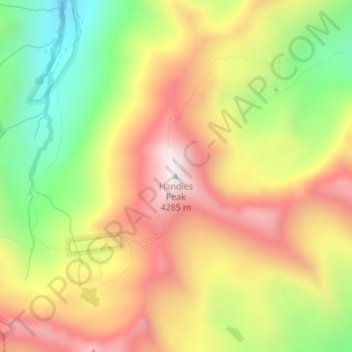
Name: Handies Peak topographic map, elevation, terrain.
Location: Handies Peak, Hinsdale County, Colorado, United States (37.91294 -107.50450 37.91304 -107.50440)
Average elevation: 12,753 ft
Minimum elevation: 11,421 ft
Maximum elevation: 13,993 ft
Hinsdale County trails, hiking, mountain biking, running and outdoor activities
Make a donation
Gear up for your next adventure:
As an Amazon Associate, this site earns from qualifying purchases at no extra cost to you.
Other topographic maps
Click on a map to view its topography, its elevation and its terrain.
Lake City
United States > Colorado > Hinsdale County
Lake City experiences a continental climate (Köppen climate classification Dfb) that only just escapes being classified as semi-arid due to its relatively wet early springs and late autumns. On average, the wettest month is August, and the driest is February. Very large daily temperature swings are a regular…
Average elevation: 9,298 ft
Weminuche Wilderness
United States > Colorado > Hinsdale County
The Weminuche Wilderness is a wilderness area in southwest Colorado managed by the United States Forest Service as part of the San Juan National Forest on the west side of the Continental Divide and the Rio Grande National Forest on the east side of the divide. The Weminuche Wilderness was designated by…
Average elevation: 10,036 ft
Lake City
United States > Colorado > Hinsdale County
Lake City experiences a continental climate (Köppen climate classification Dfb) that only just escapes being classified as semi-arid due to its relatively wet early springs and late autumns. On average, the wettest month is August, and the driest is February. Very large daily temperature swings are a regular…
Average elevation: 9,298 ft
Make a donation
Gear up for your next adventure:
As an Amazon Associate, this site earns from qualifying purchases at no extra cost to you.
Lake San Cristobal
United States > Colorado > Hinsdale County
Lake San Cristobal is a lake in the U.S. state of Colorado. Located in the San Juan Mountains at an elevation of 9,003 feet (2,744 m), the freshwater lake is 2.1 miles (3.4 km) long, up to 89 feet (27 m) deep, has a surface area of 0.52 square miles (1.3 km2), and holds about 11,000 acre-feet (14,000,000 m3)…
Average elevation: 9,669 ft