
Make a donation
Gear up for your next adventure:
As an Amazon Associate, this site earns from qualifying purchases at no extra cost to you.
Lahodiv topographic map
Click on the map to display elevation.
Make a donation
Gear up for your next adventure:
As an Amazon Associate, this site earns from qualifying purchases at no extra cost to you.
About this map
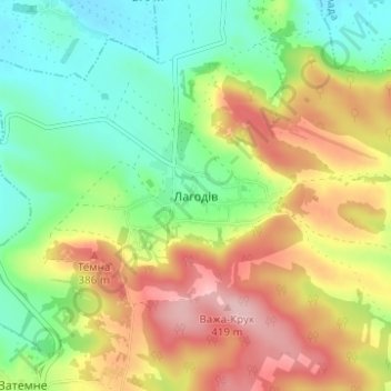
Name: Lahodiv topographic map, elevation, terrain.
Average elevation: 1,056 ft
Minimum elevation: 814 ft
Maximum elevation: 1,385 ft
Make a donation
Gear up for your next adventure:
As an Amazon Associate, this site earns from qualifying purchases at no extra cost to you.
Other topographic maps
Click on a map to view its topography, its elevation and its terrain.
Lviv
Lviv is on the edge of the Roztochia Upland, about 70 kilometres (43 miles) east of Polish border and 160 km (99 mi) north of the eastern Carpathian Mountains. The average altitude of Lviv is 296 metres (971 feet) above sea level. Its highest point is the Vysokyi Zamok (High Castle), 409 meters (1342 feet)…
Average elevation: 1,014 ft
Lviv
Lviv is on the edge of the Roztochia Upland, about 70 kilometres (43 miles) east of the Polish border and 160 km (99 mi) north of the eastern Carpathian Mountains. The average altitude of Lviv is 296 metres (971 feet) above sea level. Its highest point is the Vysokyi Zamok (High Castle), 409 meters (1,342…
Average elevation: 1,014 ft
Lviv
Lviv is on the edge of the Roztochia Upland, about 70 kilometres (43 miles) east of Polish border and 160 km (99 mi) north of the eastern Carpathian Mountains. The average altitude of Lviv is 296 metres (971 feet) above sea level. Its highest point is the Vysokyi Zamok (High Castle), 409 meters (1342 feet)…
Average elevation: 1,014 ft
Make a donation
Gear up for your next adventure:
As an Amazon Associate, this site earns from qualifying purchases at no extra cost to you.
Make a donation
Gear up for your next adventure:
As an Amazon Associate, this site earns from qualifying purchases at no extra cost to you.
Make a donation
Gear up for your next adventure:
As an Amazon Associate, this site earns from qualifying purchases at no extra cost to you.
Make a donation
Gear up for your next adventure:
As an Amazon Associate, this site earns from qualifying purchases at no extra cost to you.
Lviv
Lviv is on the edge of the Roztochia Upland, about 70 kilometres (43 miles) east of the Polish border and 160 km (99 mi) north of the eastern Carpathian Mountains. The average altitude of Lviv is 296 metres (971 feet) above sea level. Its highest point is the Vysokyi Zamok (High Castle), 409 meters (1,342…
Average elevation: 1,014 ft
Make a donation
Gear up for your next adventure:
As an Amazon Associate, this site earns from qualifying purchases at no extra cost to you.
Make a donation
Gear up for your next adventure:
As an Amazon Associate, this site earns from qualifying purchases at no extra cost to you.
Make a donation
Gear up for your next adventure:
As an Amazon Associate, this site earns from qualifying purchases at no extra cost to you.
Skhidnytsia
Skhidnytsia located at an altitude of 600 metres (2,000 ft) – 900 metres (3,000 ft) above sea level. The mountains around the town reach a height of 823 metres (2,700 ft).
Average elevation: 2,044 ft
Make a donation
Gear up for your next adventure:
As an Amazon Associate, this site earns from qualifying purchases at no extra cost to you.
Make a donation
Gear up for your next adventure:
As an Amazon Associate, this site earns from qualifying purchases at no extra cost to you.
Make a donation
Gear up for your next adventure:
As an Amazon Associate, this site earns from qualifying purchases at no extra cost to you.
Ландшафтний заказник місцевого значення «Романівський»
Ukraine > Lviv Oblast > Romaniv
Average elevation: 1,358 ft
Make a donation
Gear up for your next adventure:
As an Amazon Associate, this site earns from qualifying purchases at no extra cost to you.
Make a donation
Gear up for your next adventure:
As an Amazon Associate, this site earns from qualifying purchases at no extra cost to you.
Make a donation
Gear up for your next adventure:
As an Amazon Associate, this site earns from qualifying purchases at no extra cost to you.