Geolocate

Outjo topographic map

Click on the map to display elevation.

About this map

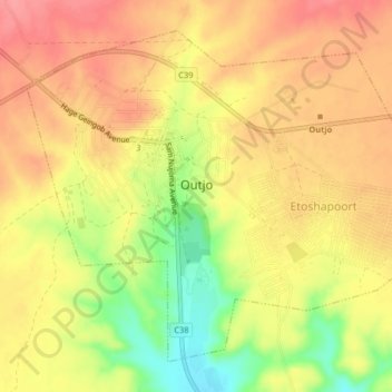
Name: Outjo topographic map, elevation, terrain.

Location: Outjo, Kunene Region, Namibia (-20.12818 16.13938 -20.09591 16.18058)

Average elevation: 4,173 ft

Minimum elevation: 4,009 ft

Maximum elevation: 4,268 ft

Other topographic maps

Click on a map to view its topography, its elevation and its terrain.

Sesfontein

Namibia > Kunene Region

Average elevation: 1,995 ft

Gear up for your next adventure:

🧦Merino Wool Socks - Moisture-wicking, blister-preventing socks for long treks
😴Insulated Sleeping Pads - Compact and warm pads for high-elevation camping
🛰️Satellite Messengers - Emergency SOS and two-way messaging for off-grid adventures
🎒Hydration Pack - Hands‑free water reservoir for long hikes
🎒Gear Packing Cubes - Organize your backpack efficiently

As an Amazon Associate, this site earns from qualifying purchases at no extra cost to you.