Geolocate

Churag topographic map

Click on the map to display elevation.

About this map

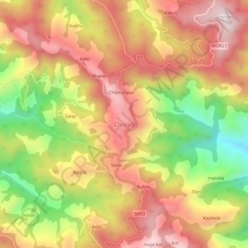
Name: Churag topographic map, elevation, terrain.

Location: Churag, Karsog, Mandi, Himachal Pradesh, 175010, India (31.33200 77.13857 31.37200 77.17857)

Average elevation: 5,774 ft

Minimum elevation: 4,656 ft

Maximum elevation: 6,614 ft

Other topographic maps

Click on a map to view its topography, its elevation and its terrain.

Sunni

India > Himachal Pradesh > Karsog

Average elevation: 2,520 ft

Bitahli Khad

India > Himachal Pradesh > Karsog

Average elevation: 4,695 ft

Sunni

India > Himachal Pradesh > Karsog

Average elevation: 2,520 ft

Gear up for your next adventure:

🎒Gear Packing Cubes - Organize your backpack efficiently
🔭Compact Binoculars - HD vision for scouting terrain and identifying distant landmarks
🧭GPS Watch Accessories - Bands and chargers for GPS watches
🧭Outdoor Navigation Book - Learn advanced navigation skills
🎁Geography Themed Gifts - Unique gift ideas for map lovers and geography enthusiasts

As an Amazon Associate, this site earns from qualifying purchases at no extra cost to you.