Geolocate

Sunni topographic map

Click on the map to display elevation.

About this map

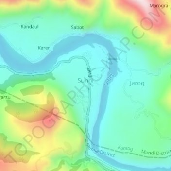
Name: Sunni topographic map, elevation, terrain.

Location: Sunni, Karsog, Mandi, Himachal Pradesh, India (31.23710 77.11981 31.24609 77.12196)

Average elevation: 2,520 ft

Minimum elevation: 2,031 ft

Maximum elevation: 3,730 ft

Other topographic maps

Click on a map to view its topography, its elevation and its terrain.

Churag

India > Himachal Pradesh > Karsog

Average elevation: 5,774 ft

Pangna

India > Himachal Pradesh > Karsog

Average elevation: 5,381 ft

Nanj

India > Himachal Pradesh > Karsog

Average elevation: 3,793 ft

Tattapani

India > Himachal Pradesh > Karsog

Average elevation: 3,465 ft

Bajandi

India > Himachal Pradesh > Karsog

Average elevation: 5,456 ft

Punanu

India > Himachal Pradesh > Karsog

Average elevation: 5,351 ft

Rihana

India > Himachal Pradesh > Karsog > Jeora

Average elevation: 3,097 ft

Khanyar

India > Himachal Pradesh > Karsog

Average elevation: 5,453 ft

Nauhra

India > Himachal Pradesh > Karsog > banthal

Average elevation: 5,236 ft

Gajeha

India > Himachal Pradesh > Karsog

Average elevation: 5,509 ft

Bhuthi

India > Himachal Pradesh > Karsog > Karsog

Average elevation: 5,279 ft

Chebar

India > Himachal Pradesh > Karsog

Average elevation: 4,439 ft

Gear up for your next adventure:

😴Insulated Sleeping Pads - Compact and warm pads for high-elevation camping
🔋Rechargeable Batteries - Power up your outdoor devices
📚USA Hiking Guide Books - Top trail guides and map books
🔭Telescopic Hiking Pole - Adjustable pole for hiking stability
📌Outdoor GPS Map App - Apps and devices for digital topographic navigation

As an Amazon Associate, this site earns from qualifying purchases at no extra cost to you.