
Whitestone topographic map
Click on the map to display elevation.
About this map
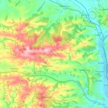
Name: Whitestone topographic map, elevation, terrain.
Average elevation: 341 ft
Minimum elevation: 20 ft
Maximum elevation: 820 ft
Other topographic maps
Click on a map to view its topography, its elevation and its terrain.
Teignmouth Beach
United Kingdom > England > Devon > Teignbridge > Teignmouth > Shaldon
Average elevation: 79 ft
Ponsworthy
United Kingdom > England > Devon > Teignbridge > Widecombe-in-the-Moor
Average elevation: 912 ft
Heltor Rock
United Kingdom > England > Devon > Teignbridge > Bridford > Westcott
Average elevation: 817 ft
Haytor Rocks
United Kingdom > England > Devon > Teignbridge > Haytor Vale > Smallacombe
Average elevation: 1,161 ft
Greatoak Cross
United Kingdom > England > Devon > Teignbridge > Abbotskerswell > Whiddon
Average elevation: 190 ft
Southbrook
United Kingdom > England > Devon > Teignbridge > Buckland in the Moor
Average elevation: 784 ft
Bonehill
United Kingdom > England > Devon > Teignbridge > Widecombe in the Moor > Bonehill
Average elevation: 1,161 ft
Holcombe Down
United Kingdom > England > Devon > Teignbridge > Teignmouth > Holcombe Down
Average elevation: 331 ft
Lindridge Park
United Kingdom > England > Devon > Teignbridge > Luton > Humber
Average elevation: 410 ft